[<][<=][=>]Index of this webpage
**++Climatology from Satellites Group++**
**++Postgraduate++**
++Current Research Assistants (and Doctorate Students):++
++Doctorate on Remote Sensing Students:++
++Master Postgraduate:++
++Master Students:++
++Advanced Undergraduate:++
++Practicum - Practical Training:++
++Current External:++
++Past ..., but very close to us ...:++
**++Publications++**
**++Links to Significant Meetings++**
''**++2015++**''
''**++2014++**''
**++Active Collaborations++**
**++Acknowledgments**++
**++Book suggestions++**
**++Link of the Day++** (in reality, ... every now and then)
2013
December
**++Teaching Subjects++**
Postgraduate Course on ''New Observation and Watching Systems in Meteorology and Climatology''
**Some Teaching Publications**
**++Research Lines++**
**''I Validation of low spatial resolution remote sensing data and products (GERB, SMOS, EPS/MetOp, SMAP)''**
**''II Radiative balance studies (GERB, CERES, SEVIRI, EarthCARE)''**
**''III Soil moisture from passive microwaves (SMOS)''**
**++Valencia & Alacant Anchor Stations++**
**What is an ''ANCHOR STATION''**? (from Professor H.-J. Bolle)/
**Rationale**/
**Desirable measurements at ''Anchor Stations''**/
How Representative are the ''Alacant and the Valencia Anchor Stations'' Measurements of their Respective Surrounding Meteorology?
Proposal for a ''Water Cycle Observatory'': The VALENCIA and the ALACANT ANCHOR STATIONS, Meteorological Reference Stations for Remote Sensing Data and Products
**Publications**
2008
2007
2006
2005
2003
2002
**++Involvement in Satellite Earth Observation Missions++**
**SMOS (''Soil Moisture and Ocean Salinity'')**/
**SMOS Validation Rehearsal Campaign Activities at the Valencia Anchor Station**
**Scientific Team**
**Purpose**
**Activities
**SM Measurements**
**Vegetation Measurements**
**Soil texture**
**Airborne Operations during the SMOS Validation Rehearsal Campaign (Tauriainen, 2008)**
**Modelling**
**Publications**
2011
2010
2008
2007
2006
2005
2004
2003
2002
**Projects**
**EarthCARE (''Earth Clouds, Aerosols and Radiation Explorer'')**
**Publications**
2012
2011
2007
2006
2004
2003
2002
2001
**Projects**
**GERB (''Geostationary Earth Radiation Budget'')**/
**Publications**
2011
2008
2007
2006
2005
2004
2000
**Projects**
**CERES (''Clouds and the Earth's Radiant Energy System'')**/
**Publications**
2012
2008
2007
2006
2005
2004
2000
**Projects**
**EPS/MetOp (''EUMETSAT Polar System / MetOp'')**/
**Publications**
**Projects**
**++Other Significant Research Projects and Contracts++**
**Publications**
**++Field Campaigns++**
**++Supervision of Research Academic Work++**
**++Selected Significant Publications++**
**++Photographic Album: A Sample++**/
2014
2013
2012
2008
2007
2006
2005
2004
2003
2002
2001
2000
1988
[<][<=][=>][*]
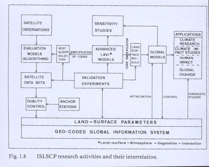
**Rationale**/
Mesoscale models
can in principle be operated with little instantaneous input from ground observations if topography and synoptic scale flow are known. Whether they produce the correct interactions with the surface (momentum, energy and mass fluxes) must be checked at least occasionally by direct measurements
Hydrological models
The same is true. In their case, it has to be validated whether they produce the correct soil moisture and run-off
Satellite data
are evaluated with complicated algorithms that tie the measured radiances to surface properties. These algorithms have to be tested against direct measurements and satellite instruments have to be re-calibrated

(From F. Becker, H.-J. Bolle and P.R. Rowntree, 1988, The International Satellite Land Surface Climatology Project)
Climate models
Not only need in addition to meteorological data carbon dioxide and other trace gas fluxes, they also need, according to the latest results, aerosol data. Anchor Stations should therefore also be equipped with instrumentation for spectral optical depth measurements or other kind of equipment that provides information about aerosol concentrations and types. The state of vegetation can, to some degree, be estimated from satellite observations. The conclusions from such kind of measurements may, however, be misleading if no ground truth is available

