GREEN ROUTE: NA MOLINS
Duration: 2 hours // Length: 25 km // Transportation: car,bicycle. On foot in some sections.
(Recommendations: Try to avoid times of maximum insolation, especially in summer.) |
On your walk you can enjoy a landscape dominated by rice fields, ditches, old engines with their fireplaces, farms, and a huge species of birds. A place with great cultural, natural and landscape aspects, where water is the key piece of this valuable ecosystem.
The “marjal” is an area flooded, occuped all the year, mostly by rice fields.
L'Albufera, naturally, tends to become smaller and smaller by the sediments that are slowly bringing the canyons that reach it, but this reduction is greatly accelerated since it’s began to grow rice. The original landscape has been changin, and the rice fields actually cover 14,000 Ha of the park.
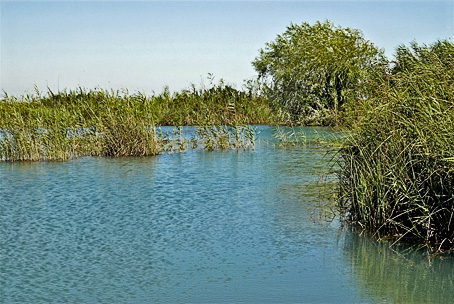
Once in the Muntanyeta dels Sants, you can visit the “Ermita del Benisants de la Pedra, San Abdón y Senén”. From here, you can enjoy an excellent view of the marjal. The “ullals” are freshwater and clean springs. There are very important, especially in the presence of rare and endangered animals, like fartets and samarucs (types of fish). The Baldoví Ullal is the largest of the springs around the natural park, with an area of 0.45 ha. And deep as three meters. Before restoration, carried out in 2006, the Ullal de Baldoví had a smaller area, and its margins only grew the typical vegetation of these marshy environments. In the reserve you can find an observatory and viewpoints, where you can recognize the more reppresentative species of animals and plants.
The most common wildlife you can see are the birds. Their number depends on the season. In winter is easy to see species of ducks, marsh harriers, gulls and herons. In summer you can see Stilts, Black Terns, Purple Herons, “Pagaza piconegras” and others. And all the year are common to find the heron, little egret and the cattle egret.
The most common plants on the edges of the ditches and ullals are the reed, cane and wicker. In spring you can see the colorful yellow lily flower or marsh. Also, around the houses and engines and their nicknames (separation between field and field), poplars and willows can see the function set in a more efficient land between rice fields.
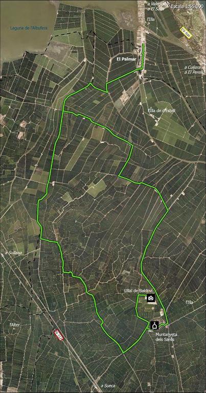
Route
Km 0. Village "El Palmar". (Start)
0.8 km. End of El Palmar. Turn right towards Sollana.
1.9 km. Step on a bridge. Turn to the left.
3.9 km. Intersection with asphalted road, go straight.
6.1 km. Continue straight on dirt road.
7.1 km. Turn to the left.
8.2 km. Asphalted road, turn right.
9.1 km. First junction turn left.
10.1 km. Junction with asphalted road. Turn left and you'll hace in front the "Muntanyeta dels Sants"
11.1 km. Turn to the right.
12.3 km. Cross paved road and continue along the dirt road. At this point, if you follow the paved road on the right would go Muntanyeta dels Sants.
12.7 km. "Na Molins" reserve area, in Ullal de Baldoví. We return along the same path.
Km 13. Continue straight on the paved road.
13.9 km. Turn to the left.
14.2 km. Rise to "Muntanyeta dels Sants". "Ermita dels Benisants of Pedra". Go down and turn left.
14.4 km. After passing a bridge, turn left along the "Cami de la Canal".
15.1 km. At the bifurcation,keep left (right is the "Cami de la Llosa").
Km 16.6. Continue straight.
Km 18.5. Turn left, crossing a bridge entering the "Travessia de Caro".
Km 20.4. Ricardo Alarte's House. Turn right by "Camí de Trompón".
Km 23.4. Crossing. Turn to the right.
Km 24.9. Turn to the right. Back to El Palmar