[<][<=][=>]Index of this webpage
**++Climatology from Satellites Group++**
**++Postgraduate++**
++Current Research Assistants (and Doctorate Students):++
++Doctorate on Remote Sensing Students:++
++Master Postgraduate:++
++Master Students:++
++Advanced Undergraduate:++
++Practicum - Practical Training:++
++Current External:++
++Past ..., but very close to us ...:++
**++Publications++**
**++Links to Significant Meetings++**
''**++2015++**''
''**++2014++**''
**++Active Collaborations++**
**++Acknowledgments**++
**++Book suggestions++**
**++Link of the Day++** (in reality, ... every now and then)
2013
December
**++Teaching Subjects++**
Postgraduate Course on ''New Observation and Watching Systems in Meteorology and Climatology''
**Some Teaching Publications**
**++Research Lines++**
**''I Validation of low spatial resolution remote sensing data and products (GERB, SMOS, EPS/MetOp, SMAP)''**
**''II Radiative balance studies (GERB, CERES, SEVIRI, EarthCARE)''**
**''III Soil moisture from passive microwaves (SMOS)''**
**++Valencia & Alacant Anchor Stations++**
**What is an ''ANCHOR STATION''**? (from Professor H.-J. Bolle)/
**Rationale**/
**Desirable measurements at ''Anchor Stations''**/
How Representative are the ''Alacant and the Valencia Anchor Stations'' Measurements of their Respective Surrounding Meteorology?
Proposal for a ''Water Cycle Observatory'': The VALENCIA and the ALACANT ANCHOR STATIONS, Meteorological Reference Stations for Remote Sensing Data and Products
**Publications**
2008
2007
2006
2005
2003
2002
**++Involvement in Satellite Earth Observation Missions++**
**SMOS (''Soil Moisture and Ocean Salinity'')**/
**SMOS Validation Rehearsal Campaign Activities at the Valencia Anchor Station**
**Scientific Team**
**Purpose**
**Activities
**SM Measurements**
**Vegetation Measurements**
**Soil texture**
**Airborne Operations during the SMOS Validation Rehearsal Campaign (Tauriainen, 2008)**
**Modelling**
**Publications**
2011
2010
2008
2007
2006
2005
2004
2003
2002
**Projects**
**EarthCARE (''Earth Clouds, Aerosols and Radiation Explorer'')**
**Publications**
2012
2011
2007
2006
2004
2003
2002
2001
**Projects**
**GERB (''Geostationary Earth Radiation Budget'')**/
**Publications**
2011
2008
2007
2006
2005
2004
2000
**Projects**
**CERES (''Clouds and the Earth's Radiant Energy System'')**/
**Publications**
2012
2008
2007
2006
2005
2004
2000
**Projects**
**EPS/MetOp (''EUMETSAT Polar System / MetOp'')**/
**Publications**
**Projects**
**++Other Significant Research Projects and Contracts++**
**Publications**
**++Field Campaigns++**
**++Supervision of Research Academic Work++**
**++Selected Significant Publications++**
**++Photographic Album: A Sample++**/
2014
2013
2012
2008
2007
2006
2005
2004
2003
2002
2001
2000
1988
[<][<=][=>][*]
**Modelling**
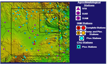
(i) At CESBIO, modelling work is currently carried out to simulate passive microwave brightness temperatures. Surfex, a SVAT (Soil-Vegetation-Atmosphere Transfer) model from Mï¿˝tï¿˝o France, is used to characterize the surface according to ground and meteorological data from the Valencia Anchor Station area. Outputs from this surface modelling are used in the L-MEB (L-band Microwave Emission of the Biosphere, Wigneron et al., 2007) model to simulate the surface emission (brightness temperatures) at L-band. These simulations, spatialized at the SMOS pixel, will be compared in a further step with the SMOS measurements during the Commissioning Phase.
(Wigneron J-P, Y. Kerr, P. Waldteufel, K. Saleh, M.-J. Escorihuela, P., Richaume, P. Ferrazzoli, P. de Rosnay, R. Gurney, J.-C. Calvet, J.P., Grant, M. Guglielmetti, B. Hornbuckle, C. Mï¿˝tzler, T. Pellarin, M. Schwank (2007): L-band Microwave Emission of the Biosphere (L-MEB) Model: Description and calibration against experimental data sets over crop fields. Remote Sens. Env., 107, p. 639-655, 2007)

Meteorological stations available for modelling and spatializing at the SMOS footprint scale
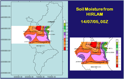
(ii) HIRLAM is currently being applied to the area. Soil Moisture fields will be extracted from HIRLAM analyses during the SMOS Validation Rehearsal Campaign and compared to the Soil Moisture network, in collaboration with the Spanish AEMet. As a trial, the picture below shows the Soil Moisture field obtained from the output from HIRLAM for 14/07/05, at 00Z. All the HIRLAM analyses will be available for the SMOS Validation Rehearsal Campaign.


