[<][<=][=>]Index of this webpage
**++Climatology from Satellites Group (GCS)++**
**++Research Lines++**
**I ''VALIDATION OF LOW SPATIAL RESOLUTION EARTH OBSERVATION REMOTE SENSING DATA AND PRODUCTS. THE VALENCIA ANCHOR STATION''**
**II ''SOIL & VEGETATION''** (tbc)
**III ''WATER STUDIES''**
**IV ''TERRESTRIAL APPLICATIONS OF GNSS-R, -IR''**
**V ''RADIATIVE BALANCE STUDIES (CERES, GERB, EarthCARE, SEVIRI)''**
**++[The Valencia Anchor Station https://tinyurl.com/yyzc4url]++**
**What is an ''ANCHOR STATION''**? (from Professor H.-J. Bolle † March 2013)
**Rationale**/
**Desirable measurements at ''Anchor Stations''**/
How Representative are the ''Valencia Anchor Stations'' measurements with respect to its surrounding meteorology?
**++Recent Research Projects++**
**++Publications++**
**Other Significant Publications++**
**++Capacity Building & Professional Education in Earth Observation**++
**++Postgraduate Course on ''New Observation and Watching Systems in Meteorology and Climatology''++**
**++Hosting Foreign Young Researchers / Students in Short Stays for I+D+i / Academic Work Activities**++
**++Acknowledgment**++
[<][<=][=>][*]
**III ''WATER STUDIES''**
III.1 Development of a reliable soil moisture network
III.2 Soil moisture upscaling and downscaling techniques
III.3 Impact of soil moisture on land surface - atmosphere interactions
III.4 Remote Sensing for Water Management Optimisation (RESEWAM-O)

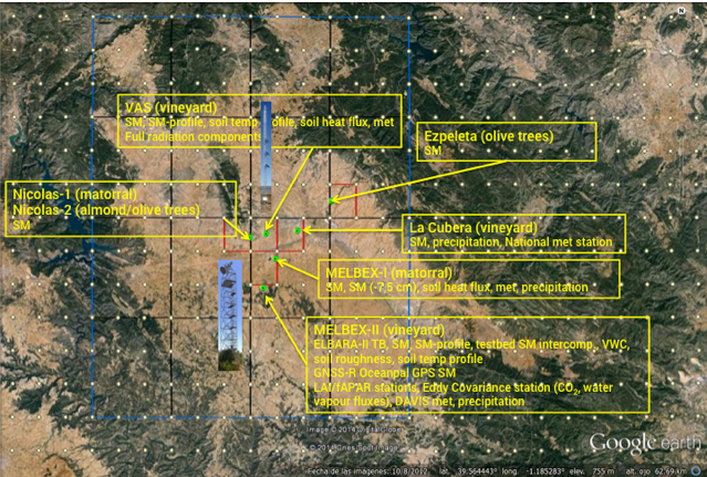
Fig. 1. Valencia Anchor Station soil moisture network

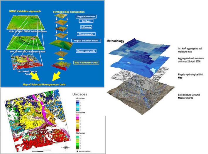
Fig. 2. Soil moisture validation methodology. Generation of ground-based soil moisture maps (upscaling) from the soil moisture network measurements through the definition of homogeneous physio-hydrological units considering soil type, vegetation cover, lithology, physiography topography, ...
(Ernesto Lopez-Baeza & the VAS Team: Ahmad Al Bitar, M. Carmen Antolin, Jan Balling, Fernando Belda, Catherine Bouzinac, Alejandro Buil, Fernando Camacho, Aurelio Cano, Ester Carbo, J. Cernicharo, M. Amparo Coll, Malcolm Davidson, Steven Delwart, Arancha Fidalgo, Achim Hahne, Silvia Juglea, Yann Kerr, Beatriz Martinez, Christian Mätzler, Susanne Mecklenburg, Arnaud Mialon, Cristina Millan, Cecilia Narbon, Mickael Parde, Fernando Requena, Kauzar Saleh, Mike Schwank, Niels Skou, Sten S. Søbjærg, Jorge Tamayo, I Torralba, Elena Torre, Ingo Voelksch, Jean-Pierre Wigneron, Patrick Wursteisen, Mehrez Zribi (2019): Towards Validation of SMOS Land Products Using the Synergy Between Models, Airborne and Ground-based Data Over the Valencia Anchor Station. Definition of Matching-up Points to SMOS Observations. IEEE International Symposium on Geoscience and Remote Sensing-IGARSS 2010. Remote Sensing: Global Vision for Local Action. Session on SMOS: The Beginning of an L-band Generation of Global Remote Sensed Soil Moisture Observations II. Honolulu, Hawaii, 25-30 July 2010)

