[<][<=][=>]Index of this webpage
**++Climatology from Satellites Group (GCS)++**
**++Research Lines++**
**I ''VALIDATION OF LOW SPATIAL RESOLUTION EARTH OBSERVATION REMOTE SENSING DATA AND PRODUCTS. THE VALENCIA ANCHOR STATION''**
**II ''SOIL & VEGETATION''** (tbc)
**III ''WATER STUDIES''**
**IV ''TERRESTRIAL APPLICATIONS OF GNSS-R, -IR''**
**V ''RADIATIVE BALANCE STUDIES (CERES, GERB, EarthCARE, SEVIRI)''**
**++[The Valencia Anchor Station https://tinyurl.com/yyzc4url]++**
**What is an ''ANCHOR STATION''**? (from Professor H.-J. Bolle † March 2013)
**Rationale**/
**Desirable measurements at ''Anchor Stations''**/
How Representative are the ''Valencia Anchor Stations'' measurements with respect to its surrounding meteorology?
**++Recent Research Projects++**
**++Publications++**
**Other Significant Publications++**
**++Capacity Building & Professional Education in Earth Observation**++
**++Postgraduate Course on ''New Observation and Watching Systems in Meteorology and Climatology''++**
**++Hosting Foreign Young Researchers / Students in Short Stays for I+D+i / Academic Work Activities**++
**++Acknowledgment**++
[<][<=][=>][*]
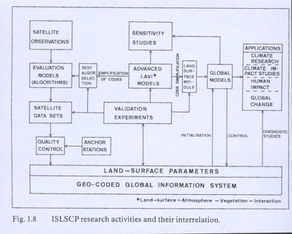
**Rationale**/
Mesoscale models
can in principle be operated with little instantaneous input from ground observations if topography and synoptic scale flow are known. Whether they produce the correct interactions with the surface (momentum, energy and mass fluxes) must be checked at least occasionally by direct measurements
Hydrological models
The same is true. In their case, it has to be validated whether they produce the correct soil moisture and run-off
Satellite data
are evaluated with complicated algorithms that tie the measured radiances to surface properties. These algorithms have to be tested against direct measurements and satellite instruments have to be re-calibrated

(From F. Becker, H.-J. Bolle and P.R. Rowntree, 1988, The International Satellite Land Surface Climatology Project)
Climate models
Not only need in addition to meteorological data carbon dioxide and other trace gas fluxes, they also need, according to the latest results, aerosol data. Anchor Stations should therefore also be equipped with instrumentation for spectral optical depth measurements or other kind of equipment that provides information about aerosol concentrations and types. The state of vegetation can, to some degree, be estimated from satellite observations. The conclusions from such kind of measurements may, however, be misleading if no ground truth is available

