This web site is intended to be useful to all the people involved in the campaign activities carried out in Barrax, La Mancha, Spain, during June and July 2005.
Last update
7 december 2005 - 16:00h
|
PROJECT 7 december Data Acquisition REPORT available hereMISSION 2 23 november New CASI processed quicklook available here29 JULY New AHS-INTA Reports available here 28 JULY After some problems with the webspace, finally the AHS-INTA Quicklooks are ready to be downloaded here 18 JULY AHS-INTA Quicklooks availables here 15 july Sen2flex Mission 2 has already finished. Congratulations to all participants 8 JULY New flightlines MAPS available HERE |
|
mission 1 9 June INTA’s Mission-1 AHS+CASI Flight Campaign Report available CHRIS/PROBA Mission-1 Quicklooks: 5-June, 6-June 3 JUNE SEN2FLEX Mission 1 campaign ended
successfully CASI finally installed at INTA aircraft. All meetings will be held at main meetings
room at 30 May – 19:00 Plenary Meeting to start SEN2FLEX 29 May – 20:00 First review meeting AIRFLEX will fly an extra line over the Alarcon
reservoir for calibration CASI will fly together with AHS instead of
AIRFLEX 25 May First test flight of the new version of AIRFLEX
at DLR, 20 May CHRIS/PROBA acquisition of Barrax test site,
The Sen2Flex web site has been opened. Today, 21st of June Sen2Flex Campaign web site has been opened to public access. The LEO Group has decided to publish this web page as an urgent response to the increasing interest in the field campaign. We are working hard to offer valuable content to all the people involved in the campaign. |
Overview of the campaign
THE SEN2FLEX CAMPAIGN
In the framework of its Earth Observation Envelope Programme the European Space Agency (ESA) carries out a number of ground-based and airborne campaigns to support geophysical algorithm development, calibration/validation and the simulation of future spaceborne Earth Observation missions.
The SENtinel-2 and FLuorescence EXperiment (SEN2FLEX) is a campaign that combines different activities in support of initiatives related both to fluorescence experiments (AIRFLEX) for observation of solar induced fluorescence signal over multiple surface targets and to GMES Sentinel-2 initiative for prototyping of spectral bands, spectral widths, and spatial/temporal resolutions to meet mission requirements. Both initiatives require simultaneous airborne hyperspectral and ground measurements for interpretation of fluorescence signal levels (AIRFLEX), and simulation of an optical observing system capable to assess geo- and bio-physical variables and to classify target surfaces by spectral, spatial and temporal distinction (Sentinel-2).
Furthermore, SEN2FLEX campaign includes activities in support of the EC Water Framework Directive (WFD) EO projects for the improvement of protection and management of Europe’s water resources.
The objectives of the SEN2FLEX campaign are
· To observe solar induced fluorescence signal over multiple agricultural and forest targets to verify signal suitability for observations from space as proposed in the FLEX EO mission
· To provide feedback to the Agency on key issues related to the definition of the ESA Sentinel-2 multispectral mission requirements. This includes the simulation of Sentinel-2 products using different sensor configurations (spatial/spectral/temporal coverage) and the evaluation of product performance as a function of configuration.
· To validate retrieval algorithms based on hyperspectral and fluorescence signals.
· To provide feedback to the Agency on EO data requirements necessary to fulfil the EU Water Policy directive.
The above objectives require the coordinated collection of satellite, airborne hyperspectral and coincident in-situ data along with preliminary analysis of the joint dataset. Two campaigns at different time period during the year are foreseen to ensure different crop growth stages and conditions. The first is to be carried out in early June 2005 and the second in mid July 2005.
It is foreseen that following airborne and spaceborne datasets will be made available for SEN2FLEX.
(a) Airborne
· AIRFLEX (APMFD) airborne multi-wavelength passive fluorescence detector operated to cope with the campaign objectives
· CASI3 airborne hyperspectral system covering the 400-1050 nm spectral region
· AHS airborne hyperspectral scanner covering the following spectral regions: 445-1015 nm (20 bands), 1550-1750 nm (1 band), 2000-2553 nm (42 bands), 3450-5250 nm (7 bands), and 8400-12450 nm (10 bands). The system shall be properly calibrated and operated with flight and instrument modalities to cope with the campaign objectives
(b) Spaceborne:
· CHRIS/PROBA, Landsat, and MERIS spaceborne sensors to collect representative measurements over the Barrax test site during the campaign time windows
Acquisitions are to be coordinated with in-situ measurements:
· Atmospheric measurements required for satellite/airborne data atmospheric corrections (radio soundings, atmospheric characterisation by means of sun photometers, aerosols lidar and atmospheric particle counters)
· LAI, fCover and Cab measurements
· Leaf reflectance, transmittance measurements
· Leaf dry matter and water content
· Leaf pigments laboratory analysis for complete pigments characterisation
· Biomass and soil moisture measurements
· Plants 3D structure characterisation and mapping
· Surface radiometric characterisation
· Surface energy/water/CO2 fluxes
· Thermal and emissivity surface measurements
After pre-processing and scientific analysis, the experiment data will be delivered to ESA in a format to be agreed to with the Agency.
In order to properly document all the activities, the following reports must be prepared along the project:
Experiment Plan
The Contractor shall prepare an experiment plan for approval by the Agency at a pre-campaign meeting. The experiment plan shall provide a detailed definition of the Contractor’s contribution to the campaign. The experiment plan shall give a description of all other instruments used in the campaigns and define the data to be acquired. It shall describe the operations to be performed during the campaign as well as the data processing and analysis after the data acquisition. The plan shall also include a schedule of these activities.
Data Acquisition Report
The Contractor shall prepare a data acquisition report. The data acquisition report shall be a concise document and shall describe the instrumentation used, the measurements made by the sensors under the Contractor's responsibility, and the data processing to be applied to the data.
Data Processing Progress Report
The Contractor shall prepare a data processing report to be delivered prior to the preliminary results meeting to review the initial results of the campaign. This report shall focus on the results of the processing of the data and on the first findings.
Final Scientific Analysis Report
The Contractor shall prepare a scientific analysis report. This report shall address all aspects of the organisation and the execution of the campaign as well as the data acquisition of the SEN2FLEX campaign under the Contractor's responsibility. The report shall also discuss in detail the data analysis methods used and the scientific results of the campaign. This report shall be the final report of the campaign.
SCHEDULE OF ACTIVITIES
The following campaign schedule is suggested. The Contractor will propose an updated schedule in the experiment plan:
| Kick-off
meeting |
ESTEC (by phone) |
March 2005
|
| Delivery
of experiment plan
|
|
April 2005 |
| Pre-campaign
meeting |
Barrax, Spain |
May 2005
|
| SEN2FLEX
1st campaign |
|
June 2005
|
| SEN2FLEX
2nd campaign |
|
July 2005
|
| Data
acquisition report |
|
September 2005
|
| Preliminary
results meeting |
Valencia, Spain |
November
2005
|
| Data
delivery and scientific analysis report
|
|
January 2006
|
| Final
SEN2FLEX presentation
|
ESTEC |
February 2006 |
MEETINGS
This study shall last 12 months from kick-off to the delivery of campaign data and all reports. The following meetings shall be held as indicated below.
|
Kick-off
meeting
|
Phone |
March,
2005 |
|
Pre-campaign
meeting
|
Barrax,
Spain |
May, 2005 |
|
Preliminary
results meeting
|
Valencia,
Spain |
November, 2005 |
|
Final SEN2FLEX
presentation
|
ESTEC |
February 2006 |
CAMPAIGN OVERVIEW
The main campaign component is based on the AIRFLEX flights, in preparation of a future Vegetation Fluorescence Mission. These will be the first scientific flights of the AIRFLEX instrument after the engineering flight carried out last October at DLR in
Germany. The AIRFLEX instrument will fly on an aircraft provided by DLR, together an imaging spectrometer (CASI-3) in the same aircraft in order to collect high spectral resolution reflectance data simultaneously to passive fluorescence measurements. Flights will take place in La Mancha, Spain, by the first week of June and the third week of July (pending confirmation of aircraft availability and other constraints).
A second campaign objective is the preparation of the Sentinel missions, the GMES component of future operational missions (follow-on of Landsat type of missions oriented to operational applications). The Sentinel missions are currently under definition. The baseline is a kind of Landsat-TM type of instrument, an our next campaign is supposed to be used to define enhancements in spectral capabilities for such Sentinel mission over current Landsat capabilities. In order to cover the SWIR and TIR spectral regions we plan to use the INTA AHS instrument as complement to CASI.
A third aspect of the campaign is the GMES activities within the EU Water directives, to be covered as part of on-going GMES projects.
Field measurements to be collected during both campaign windows (first week of June and third week of July) would be similar to the field measurements carried out in previous campaigns, with the only difference that this year we would have two campaigns rather than one. Some instruments would be deployed in the field the whole time between the two missions in order to collect longer time series.
(A) THE AIRFLEX INSTRUMENT FOR VEGETATION FLUORESCENCE MEASUREMENTS
In the framework of the Earth Observation Preparatory Programme of the European Space Agency a study was launched in 2003 to design and build an interference-filter Airborne Multi-Wavelength Passive Fluorescence Detector (APMFD).
AIRFLEX specifications:
O2-A Band: 757.50 & 760.59 nm / 1 nm
O2-B Band: 684.91 & 687.02 nm / 0.5 nm
PRI Band: 531 & 570 nm / 5 nm
Field of View: 34 mrad
Footprint: 20 m at 600 m of altitude
Useful Pupil Diameter: 20.5 mm
Detection: PIN Si photodiode (f 2.54 mm)
Integration time: 20 ms or 200 ms
Samples / s: 12 or 2.2
PHYSICAL PARAMETERS PROVIDED BY AIRFLEX
Fluorescence at 687 and 760 nm
Reflectance at 687, 760, 531 and 570 nm
PRI index = (R531-R570)/(R531+R570)
NDVI index = (R760-R687)/(R760+R687)
RF/FRF ratio = F687/F760
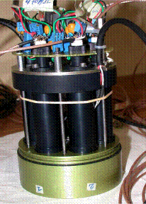
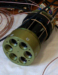
The AIRFLEX instrument for vegetation fluorescence measurements
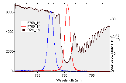
Atmospheric transmission, with indication of the positions od AIRFLEX bands
(B) THE SENTINEL-2 MISSION
In the frame of the Global Monitoring for Environment and Security programme (GMES), ESA is undertaking the development of the Sentinel-2, a European polar orbit satellite system combining high and low resolution superspectral imagers and focussing on the monitoring of terrestrial surfaces and their evolution with time. This mission will ensure the continuation of SPOT-type measurements (including VEGETATION), Envisat/MERIS for terrestrial applications and Landsat/ETM+.
GMES is a joint initiative of the European Commission (EC) and the European Space Agency (ESA), designed to establish a European capacity for the provision and use of operational information for GMES. In 2008 the foundations and the structuring elements of the European Capacity for Global Monitoring of Environment and Security should be in place and operating.
This Capacity is seen to be composed of three modules, which together constitute the functional GMES "system": (1) The production and dissemination of information in support of EU policies for Environment and Security; (2) The mechanisms needed to ensure a permanent dialogue between all stakeholders and in particular between providers and users; (3) The legal, financial, organisational and institutional frame to ensure the functioning of the system and its evolution.
In the context of ESAs role to provide the definition and the development of the space-related system elements GMES Sentinel-2 provides continuity to the service of supplying superspectral optical image data over global terrestrial surfaces on an operational basis. Sentinel-2 will capitalise on the technology and the vast experience acquired in Europe and the US with systems such as SPOT and Landsat families over the past decades, as well as with global terrestrial observing sensors such as VEGETATION, MERIS and MODIS. Three priority areas have been identified for regional and global applications:
- Improvement of land surface classifications;
- Quantitative analysis of vegetation, soil and hydrological processes as well as natural hazards
- Monitoring and assessment of land use and land cover change.
Concerning in partuicular Water Management and Soil Protection, the Service for the Provision of Advanced Geo-Information on Environmental Pressure and State (SAGE) aims at a comprehensive range of products to serve the demands coming from the European Water Framework Directive and the upcoming regulations of the Thematic Strategy on Soil Protection usually referred to as Soil Thematic Strategy. Public and private partners together have established core services addressing basic geo-information needs of the environmental community. They mainly address water availability and water stress related issues as well as anthropogenic influence on surface and ground water quality. These services are the basis of customised end-user applications supporting the national and local implementation of the European Water Framework Directive and Soil Thematic Strategy.
The distinction of green vegetation, non photosynthetic vegetation and soils is of high relevance for services associated with Aqua/Soil-SAGE. The detection of vegetation stress and soil degradation are also important indicators that drive the spectral performance of Sentinel-2. Based on the experience with the programmability of spectral bands in the MERIS sensor on Envisat, it is recommended to also keep the Sentinel-2 spectral bands programmable in their spectral position, thus enabling (during the definition and development phase) their optimisation w.r.t. algorithm and product developments and consequently the services. This programmability would not apply to MIR and TIR spectral bands.
The Sen2flex campaign has been designed in such a way that all the spectral configurations between Landsat-TM and SPECTRA can be tested with the combination CASI+AHS. Anticipating that the spectral capabilities of Sentinel-2 would be somehow in between ThematicMapper and those planned for SPECTRA, we should be able to get the alternatives in between with the current setup. Since data will be collected in high spatial resolution, spatial degradation can be used to test resolution requirements for each alternative spectral configuration. The basic idea is to compare Sentinel-2 products with Landsat-TM products (taken as baseline) and SPECTRA-like products (taken as optimum), and then analise potential intermediate cases.
(C) GMES / EU WATER POLICY DIRECTIVE
The Framework Directive addresses the following objectives:
- Protects all waters - rivers, lakes, coastal waters, and groundwaters.
- Sets ambitious objectives to ensure that all waters meet good status by 2015.
- Sets up a system of management within river basins that recognises that water systems do not stop at political borders.
- Requires cross border co-operation between countries and all involved parties.
- Ensures active participation of all stakeholders, including NGOs and local communities, in water management activities.
- Ensures reduction and control of pollution from all sources like agriculture, industrial activity, and urban areas, etc.
- Requires water pricing policies and ensures that the polluter pays.
- Balances the interests of the environment with those who depend on it.
The Sen2flex activities in relation to GMES/Water aspects will focus is on methodological questions related to a common understanding of the technical and scientific implications of the Water Framework Directive. The aim is to clarify and develop, where appropriate, supporting technical and scientific information to assist in the practical implementation of the Directive, providing advice on operational methods and other supporting aspects, and developing validation methodologies to check the different proposed scenerios by means of dedicated field measurements and with the help of Earth Observation methodologies.
Taking advantage of the fact that the study area used in the Sen2flex campaign is one of the Pilot River Basins defined in the Water Framework Directive, any activity in the framework of Sen2flex in La Mancha will become representative of the type of actions suggested in the implementation strategy.
Some of the activities defined in the Directive implementation document are:
- Establishment of reference conditions and reference sites for the inter-calibration network;
- Preparation for specification of values for the ecological status classification systems;
- Analyses of the characteristics of the river basin, of pressures and impacts and the economics of water use.
All such aspects can be addressed as part of Sen2flex activities in relation to the Water Framework Directive, to help definition of operational monitoring programmes that can serve to implement the River Basin Management Plans.
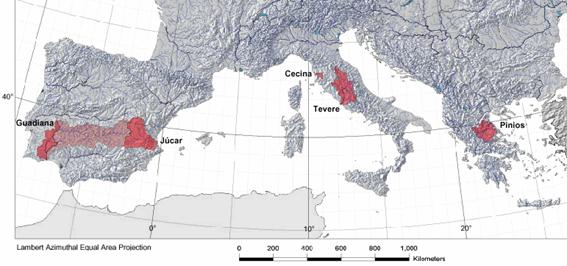
Water Framework Directive Pilot River Basins