|
|
||||||||||||||||||||||||||||
|
|
|
|
Congratulations to the participants since the SPARC campaign was highly
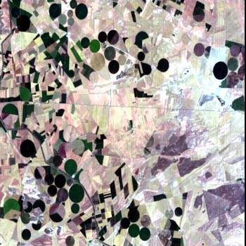
successful. Satellite acquisitions All satellite acquisitions have been successful, with very good atmospheric conditions, and the quick looks have been already posted in the respective web sites for CHRIS/PROBA and for MERIS-FR data. Although we have only seen the quick-looks by now, the geographical location seems correct and the radiometric quality seems to be as expected. The only serious problem was with the CHRIS/PROBA image of 13 July, just the one that was supposed to be in near-nadir conditions. Something was wrong with the satellite and the image definitely seems not to correspond to the Barrax site. Apparently the acquisition was successful, but the satellite was pointed to somewhere quite far away from the intended target. Fortunately, PROBA did a very good job for the two views that were quite far off-nadir on 12 and 14 July but, on the other hand, just the image of the nadir overpass is the one that was lost. Since we have not been able to identify the geographical area corresponding to the CHRIS image of 13 July, now we hope the engineers can figure out what was wrong with the satellite. The intended almost simultaneous CHRIS-MERIS acquisition was successfully acquired on 14 July, and we have in any case a quite interesting multi-scale dataset. From the CHRIS-on-PROBA Mission Web Page, here you are the quicklooks (click inside the quicklook for a bigger one) of the campaign acquisitions by this sensor over Barrax test site:
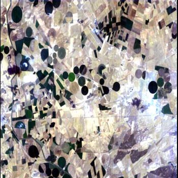
From the Envisat Catalogues Web Page, here you are the available quicklooks of the campaign acquisitions by the ESA Envisat satellite:
Airborne acquisitions The planned airborne acquisitions were successfully carried out on 12 July, one day before the date initially planned. The reason for the change was coordination with other test areas to optimise acquisitions according to weather forecasts on each site. Fortunately, the change from 13 to 12 July was quite adequate, since the reason for the flights on 13 July was the nadir-view of CHRIS/PROBA (the one that finally failed), while on the day of the flight, 12 July, we had in fact successful CHRIS acquisitions exactly simultaneous with the airborne acquisitions. Despite some problems with the instruments the days before, both HYMAP and ROSIS seem to have performed quite well during the flight over the Barrax site, and from the information we already have, the acquired data are of very good quality. A last change in the flight patterns allowed to acquire two parallel HYMAP lines instead the only one HYMAP line initially planned, while still saving flight time by optimisation of the flight plan. In this way, we have even more airborne data that what was initially planned. The coincidence of ROSIS/HYMAP airborne data with CHRIS data should allow interesting analysis in the future.
Atmospheric measurements Atmospheric data were collected as planned for each satellite / aircraft overpass, including radiosoundings (two each day), solar irradiance measurements (global and direct, spectrally resolved) and lidar data to measure the vertical aerosols profile. Although redundancy in some systems was used to guarantee data acquisition, all instruments performed without problems during the whole campaign. On 14 July, in coincidence with MERIS overpass, an Optronics instruments was used to measure the incoming surface irradiance within the MERIS oxygen absorption bands with very high spectral resolution, to test algorithms used to get surface pressure in MERIS data processing.
Surface radiometric measurements In coincidence with each overpass, around noon every day of the campaign, radiometric measurements were performed over a series of large homogeneous bare soil targets, as well as over some large homogeneous vegetation targets, to check sensors calibration and to validate atmospheric correction procedures to be applied to the different satellite and airborne data. A team from DLR was in the field in coincidence with the HYMAP/ROSIS acquisitions, while other 3 available radiometers were used in the other days to repeat radiometric measurements over each target for each overpass. Intercomparisons of radiometers were also performed. Several thermal radiometers were also used to get surface temperature and emissivity data for parallel studies and validation of ENVISAT AATSR data.
Vegetation measurements All vegetation measurements were performed as planned, and with an enormous effort from all the participants (field measurements took place from 6:00h to 22:00h LT) we have been able to collect even more samples than initially planned. In total we have over 4000 LAI samples (many more than the expected), representing over 100 statistically representative sampling regions. Moreover, for some crops we have duplicated measurements for quality check, and intercomparison of techniques for crops with some more structure. Destructive sampling was even used in one case to check validity of readings with indirect methods for crops with very high values. With all the cross-testing, we are quite sure that the values of LAI reported are correct in mean values, and also statistically representative to describe variance in each sampled area. The range of LAI values measured for a total of 7 different crop types goes from near zero to more than six, what means we have sampled all the possible LAI values for agricultural areas (0 - 6). A similar number of chlorophyll samples is available, together with 55 laboratory analysis for all crops to cross-check indirect methods used in the intensive sampling. All other measurements to describe canopy properties, including canopy hemispherical photographs, were also performed as planned. fCover and other parameters describing canopy structure can be obtained from the analysis of the many acquired vertical-looking and hemispherical photographs. Leaf samples were dried in ovens to derive water content and computed specific leaf biomass. Detailed maps of crop types and status were produced, updated for the days of the campaign, and all crops were extensively documented in digital pictures to facilitate posterior data interpretation.
Final comment and futher activities Despite problems with some instruments, as in every campaign, the fact of having redundant capabilities was demonstrated to be essential to guarantee a successful complete data acquisition. In general, we can really say that the SPARC campaign was highly successful, and the acquired dataset will for sure serve as reference for many studies in the next few years. The first SPARC Progress Meeting, a Data Review Meeting, is scheduled in Valencia by the end of November, while the SPARC Final Presentation is scheduled for May 2004 at ESTEC. |
|||||||||||||||||||||||||||
| • by LEO Group • University of Valencia (Spain) • | • SPARC main page • |