MATERIALS AND
METHODS
Modern Database. The Modern
Analog Technique requires access to a large modern database that
captures much of the variability present in modern faunas. Our
modern Pacific database (Appendix) is a component of the global
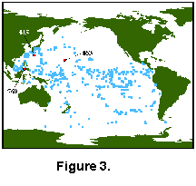
planktonic coretop database described by Prell (1985) and used by many workers. The Pacific
database (Fig. 3)
 has
499 coretop faunal analyses from the work of Thompson (1976, 1981),
Parker and Berger (1971), Coulborn et al. (1980), and some unpublished data. The samples are
distributed from 47° N to 64° S and represent winter and summer
temperatures between 0°C and 30.3°C. For this study we
regrouped the modern faunal data into the same species groups as Dowsett and Poore (1990) and Dowsett (1991) with the following changes. Species with no
more than one individual in a sample were deleted from the
dataset at the outset. Dowsett and Poore (1990) combined sinistral and dextral coiling
varieties of Neogloboquadrina pachyderma with the
artificial N. pachyderma - N. dutertrei intergrade
category of Kipp (1976) to create a "cold" end member Neogloboquadrina
category for the North Atlantic. The modern "warm" Neogloboquadrina
end member consists of N. dutertrei which is important in
low-latitude and gyre-margin upwelling regions (Dowsett 1991). In this study we chose to leave the N.
pachyderma categories and N. dutertrei - N. pachyderma
category as distinct elements of the modern fauna. These
conventions resulted in 21 counting categories (Table
1).
has
499 coretop faunal analyses from the work of Thompson (1976, 1981),
Parker and Berger (1971), Coulborn et al. (1980), and some unpublished data. The samples are
distributed from 47° N to 64° S and represent winter and summer
temperatures between 0°C and 30.3°C. For this study we
regrouped the modern faunal data into the same species groups as Dowsett and Poore (1990) and Dowsett (1991) with the following changes. Species with no
more than one individual in a sample were deleted from the
dataset at the outset. Dowsett and Poore (1990) combined sinistral and dextral coiling
varieties of Neogloboquadrina pachyderma with the
artificial N. pachyderma - N. dutertrei intergrade
category of Kipp (1976) to create a "cold" end member Neogloboquadrina
category for the North Atlantic. The modern "warm" Neogloboquadrina
end member consists of N. dutertrei which is important in
low-latitude and gyre-margin upwelling regions (Dowsett 1991). In this study we chose to leave the N.
pachyderma categories and N. dutertrei - N. pachyderma
category as distinct elements of the modern fauna. These
conventions resulted in 21 counting categories (Table
1).
Sample Preparation, Counting
Techniques and Taxonomy. To test the MAT, three Pliocene
sequences were selected from the western North Pacific (Fig. 3).
These deep-sea cores represent a range of oceanographic
conditions and thus provide a good test of the MAT technique.
The samples used in this study were
washed using low temperature (isotope) procedures. Sediment
samples were dried in an oven at less than or equal to 50°C and
weighed. The dried bulk sample was disaggregated in a beaker with
warm tap water and about 2 ml of dilute Calgon ™ solution
(5 gm Calgon ™ to 1 liter water). The beaker was agitated
on a vibrating hot plate without heating. Samples were then
washed through a 63 micron sieve using a fine spray hose and
dried in an oven at less than or equal to 50° C. Ocean Drilling
Program Hole 769B samples required an additional treatment with
NaCO3 added to the wash in order to obtain clean
specimens. Weights were then obtained for the fine and coarse
fractions of each sample.
A split of 300 to 350 planktonic
foraminifer specimens was obtained from the >149 micron size
fraction of each sample using a Carpco ™ sample splitter.
Specimens were identified, sorted, and fixed to a standard
60-square micropaleontological slide. The taxonomic names used in
Tables 2, 3, and
4 are
summarized in Polanco and Dowsett (1993) and Dowsett and West (1993). In general, our taxonomic concepts follow Parker (1962, 1967)
and Blow (1969). Pliocene census data were retabulated and
converted to percent using the same counting categories used in
the modern database. Deep Sea Drilling Project and ODP sample
designations are abbreviated as core-section, depth within
section in centimeters (e.g., 10-5, 34 = core 10, section 5, 34
cm below top of section 5). The depth column lists depth of
sample below sea floor in meters. Wherever ages are provided they
refer to the Berggren et al. (1985) time scale.
 DSDP
Site 445, Hole 445. Deep Sea Drilling Project Hole 445 was
drilled on the Daito Ridge in the Northern Philippine Sea
(25.52°N, 133.20°E) in 3377 meters of water. The upper 150 m of
sediment recovered at Hole 445 consists of nannofossil ooze with
interbedded foraminifer-nannofossil oozes (Klein et al. 1980). Calcareous microfossils are, over certain
intervals, abundant and well preserved at this locality (Echols 1980, Okada 1980). From selected microfossil datums (Echols 1980, Okada 1980), we determined that cores 10 through 12
represent the middle Pliocene. Twenty-three samples between the
bottom of Core 8 and the top of Core 13 were chosen for this
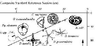
study. Graphic correlation was used (Fig. 4) to determine the relationship between
depth at Hole 445 and the composite standard reference section
(CSRS) of Dowsett (1989a,b). Depth in Hole 445 can be converted
to composite units (cu) using the equation:
DSDP
Site 445, Hole 445. Deep Sea Drilling Project Hole 445 was
drilled on the Daito Ridge in the Northern Philippine Sea
(25.52°N, 133.20°E) in 3377 meters of water. The upper 150 m of
sediment recovered at Hole 445 consists of nannofossil ooze with
interbedded foraminifer-nannofossil oozes (Klein et al. 1980). Calcareous microfossils are, over certain
intervals, abundant and well preserved at this locality (Echols 1980, Okada 1980). From selected microfossil datums (Echols 1980, Okada 1980), we determined that cores 10 through 12
represent the middle Pliocene. Twenty-three samples between the
bottom of Core 8 and the top of Core 13 were chosen for this
study. Graphic correlation was used (Fig. 4) to determine the relationship between
depth at Hole 445 and the composite standard reference section
(CSRS) of Dowsett (1989a,b). Depth in Hole 445 can be converted
to composite units (cu) using the equation:
y = 8.48 +
0.874 x, for x > 20 and x < 120 (2)
where x is depth in Hole 445 in
meters and y is composite unit position of the CSRS of Dowsett (1989a, b).
This line of correlation is well constrained down through Core 10
by the last occurrences of Helicosphaera selli, Calcidiscus
macintyrei, Discoaster pentaradiatus, Dentoglobigerina altispira,
and Sphaeroidinellopsis spp., and the first occurrence
of Globorotalia truncatulinoides. Equation (2) is used
between 20 and 120 m sub-bottom. Because the CSRS of Dowsett (1989a, b)
exhibits a nearly linear fit to absolute age, CSRS position can
be converted to absolute age using the equation:
y = 0.354 +
0.034 x (r2 = 0.99) (3)
where y is age in Ma (Berggren et al. 1985) and x is composite unit position of the
CSRS. Applying equations (2) and (3) above to the samples chosen
for this study indicates an age range of 3.82 Ma to 2.56 Ma.
Faunal census data for Hole 445 is
given in Table 2 (Dowsett and West 1993). The fauna is a typical Pliocene
subtropical assemblage with significant proportions of Globigerinoides
obliquus, Globigerinoides ruber, Globigerinoides
sacculifer, Globorotalia crassaformis, Globorotalia menardii,
Globigerina woodi, Globigerina incisa, andNeogloboquadrina
acostaensis. Large numbers of fragments in some samples are
correlated with higher percentages of benthic foraminifers and
are suggestive of increased dissolution.
 DSDP Site 463, Hole 463. Hole 463 is
located in the central North Pacific on the mid-Pacific Mountains
at 21.35° N and 174.66°E in 2525 meters of water (Fig. 3). The
upper 50 m of Hole 463 consists of highly disturbed, bioturbated,
and sometimes soupy nannofossil ooze (Thiede and Vallier et al.
1981). The stratigraphic
distribution of foraminifers (Vincent 1981, Polanco and Dowsett 1993) suggests a very low sediment accumulation
rate with the Miocene-Pliocene boundary occurring approximately
25 m sub-bottom (top of core 4). Twenty-three samples from cores
1 through 4 were processed and analyzed for planktonic
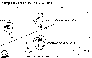
foraminifers. Graphic correlation analysis was performed on these
samples using planktonic foraminiferal events from Vincent (1981) and Polanco and Dowsett (1993, see Fig. 5). The distribution of events in Figure 5
indicates a "channel" (Shaw 1964) in which the line of correlation (LOC) can
be placed. The low number of events results in a fairly broad
channel, and the LOC shown in Figure 5 represents only a general
correlation. This LOC can be meaningfully applied between about
19 m and 5 m sub-bottom. Using the equations of the LOC:
DSDP Site 463, Hole 463. Hole 463 is
located in the central North Pacific on the mid-Pacific Mountains
at 21.35° N and 174.66°E in 2525 meters of water (Fig. 3). The
upper 50 m of Hole 463 consists of highly disturbed, bioturbated,
and sometimes soupy nannofossil ooze (Thiede and Vallier et al.
1981). The stratigraphic
distribution of foraminifers (Vincent 1981, Polanco and Dowsett 1993) suggests a very low sediment accumulation
rate with the Miocene-Pliocene boundary occurring approximately
25 m sub-bottom (top of core 4). Twenty-three samples from cores
1 through 4 were processed and analyzed for planktonic
foraminifers. Graphic correlation analysis was performed on these
samples using planktonic foraminiferal events from Vincent (1981) and Polanco and Dowsett (1993, see Fig. 5). The distribution of events in Figure 5
indicates a "channel" (Shaw 1964) in which the line of correlation (LOC) can
be placed. The low number of events results in a fairly broad
channel, and the LOC shown in Figure 5 represents only a general
correlation. This LOC can be meaningfully applied between about
19 m and 5 m sub-bottom. Using the equations of the LOC:
y = -20.94
+ 10.84 x for x < 14.5 (4)
y = 78.00 +
2.8 x for x > 14.5 (5)
and equation (3) above, absolute
ages can be derived for most of the samples in the census data
set. This age model shows our sample spacing to be inadequate to
capture any of the oceanographic variability known to exist at
Milankovitch periodicities during the Pliocene.
Planktonic foraminifer census data
for Hole 463 are presented in Table 3 (Polanco and Dowsett 1993). These samples are dominated by Globigerinoides
obliquus, Globigerinoides ruber, Globigerinoides sacculifer,
Dentoglobigerina altispira, Globigerina woodi, Orbulina universa,and
Sphaeroidinellopsis spp. High numbers of fragmented specimens
and high percentages of benthic foraminifers in some samples
suggest increased dissolution.
ODP Site 769, Hole 769B.
Hole 769B (8.78°N, 121.29°E) is located on the southeastern
flank of the Cagayan Ridge in the Sulu Sea in 3643 m of water
(Fig. 3). The upper 18 cores recovered nearly 170 m of pelagic
biogenic carbonate sediment and hemipelagic clays. Planktonic
foraminifers are abundant and fair to moderately well-preserved
in these samples with preservation diminishing due to increased
dissolution downcore.
Rangin et al. (1990) interpreted the paleomagnetic stratigraphy
to indicate the Gauss-Matuyama Chron boundary at 114.5 mbsf. The
top of the Kaena subchron occurs at 117.0 mbsf and the bottom of
the Cochiti occurs at 132.6 mbsf (Fig. 6). 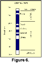 We
interpolated between these boundaries using the Berggren et al. (1985) time scale to derive ages for 26 samples
from cores 13, 14 (mid Gauss) and 18. This age model suggests
these samples are more-or-less equally distributed between about
3.4 and 2.3 Ma with the core 18 samples clustering near 5.3 Ma.
Planktonic foraminifer biostratigraphy generally supports these
age assignments.
We
interpolated between these boundaries using the Berggren et al. (1985) time scale to derive ages for 26 samples
from cores 13, 14 (mid Gauss) and 18. This age model suggests
these samples are more-or-less equally distributed between about
3.4 and 2.3 Ma with the core 18 samples clustering near 5.3 Ma.
Planktonic foraminifer biostratigraphy generally supports these
age assignments.
Planktonic foraminifer census data
for Hole 769B are given in Table 4 (Polanco and Dowsett 1993). The assemblage is typical of tropical
Pacific assemblages with high numbers of Globigerinoides,
Globorotalia, and warm water Neogloboquadrina species.
Fragment data was not generated for Hole 769B, but the high
percentages of benthic taxa in many samples with very low numbers
of planktonic specimens per 10 cc of raw material are indicative
of severe dissolution.