|
A representation of the
city: Valencia between 1563 and 1929
From
May
19st to
October 16th 2005
Estudi General exhibition room
- La Nau
From
Tuesday to Saturday, from 10 to 13.30 and from 16 to 20 h.
Sunday, from 10 to 14 h.
|
|
|
|
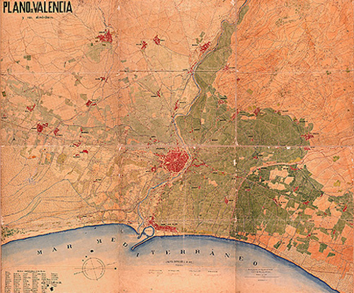
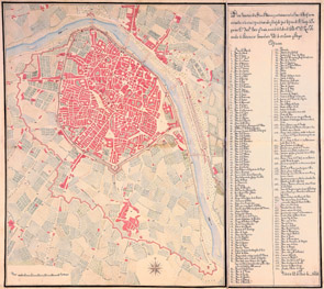
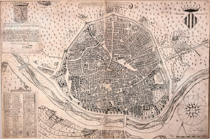
MAP OF VALENCIA and its outskirts (1883).
Army Corps General Staff. Four signatures can be seen at
the bottom corresponding to Francisco Ponce de León
(Commander Lieutenant Colonel General Staff), Jesús
Tamarit (Lieutenant Colonel, General of the Army), Pedro
Bentabol (Commander Lieutenant Colonel General Staff)
and Antonio González Samper (Staff Lieutenant). |
|
|
|
Like any other perception, perceiving a city is a
cultural phenomenon. As such, the representation of this
cognitive experience is always linked to values deemed
primordial by the dominant culture at each moment in its
own history. |
|
|
|
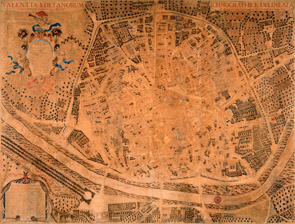
VALENCIA EDETANORUM aliis CONTESTANORUM /
vulgo DEL CID. ICHNOGRAPHICE DELINEATA / a Dre Thoma
Vincentio Tofca Congreg- Oratorij Prefbytero. Anno 1704.
(1704). Tomás Vicente Tosca |
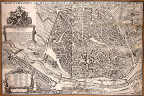
VALENTIA EDETANORUM vulgo DEL CID,
DELINEATA A Dre. THOMA VENCENTIO TOSCA CONGR. ORATORIJ
PRESBYTERO (1738 ca.). Tomás Vicente Tosca |
|
|
|
This exhibition summarises -graphically and visually-
the transformation experienced by Valencia between the
second half of the 16th century and the first
third of the 20th century. A long process
spanning from the small, conventual and desired town
depicted by Antoon van den Wijngaerde (the city
painter) in 1563 and the topographer Antonio Manceli
in 1608 to the large, unfinished and overwhelmed city
drawn by cartographers from Instituto Geográfico y
Catastral between 1929 and 1944 and faithfully
portrayed by army photographers in the first aerial
pictures. |
|
|
|
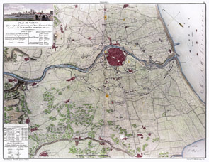
MAP OF VALENCIA / Under attack by Marshal
Moncey in 1808 (1808 r.). Anonymous work |
Geometric plan of Valencia and its
surroundings including contemporary fortresses;
elevation and drawings by Captain Francisco Cortés y
Chacón (Engineering Corps) following an order by
Commander Luis Alexandro de Bassecoúrt (1811).
Francisco Cortés y Chacón |
|
|
|
The exhibition illustrates the city idea in its
different representation forms, which requires the
previously existing city to be interpreted, as it
conditions the either fulfilled or unfulfilled project
of the subsequent one to a great extent. |
|
|
|
MAP OF
VALENCIA / Asfiegée et prise le 9 janvier 1812 par
lArmée Française dAragon Aux Ordres de S.E. LE
MARECHAL SUCHET, Duc dAlbufera.
(1812 r.). Dumoulin |
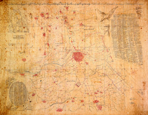
Map including topographical description
of the city of Valencia del Cid -before the Edetanians-
hamlets, orchards, the Turia river and its dams, and
irrigation channels, covering up to one league; also
including details of distinguished citizens within city
walls and outside the town. (1821). Cristóbal Sales |
|
|
|
Based on a small selection of original documents, the
exhibition uses digital reproductions of the best
printed drawings between 1608 and 1929. Although they do
describe the citys singular geometry, the large-format
pictures need to be supported by other representations
(etchings, perspectives, overviews, photographs, etc.)
to adequately define the citys unique personality. |
|
|
|
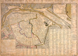
GEOMETRIC MAP OF VALENCIA DEL CID /
dedicated to THE ROYAL ECONOMIC SOCIETY by Mr Francisco
Ferrer, member of the Architecture Department of San
Carlos Fine Arts Royal Academy, 1831.
(1828). Francisco Ferrer |
NOBILIS AC REGIA CIVITAS VALENTIE IN
HISPANIA. (1608). Antonio Manceli |
|
|
|
|