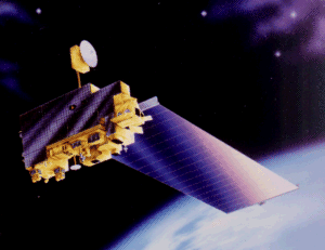
This is the new sensor MODIS (Moderate Resolution Imaging Spectroradiometer) aboard the new satellite TERRA, it was launched in 18th December 1999. The instrument, with instantaneous fields of view (IFOVs) of 250 m (bands 1-2), 500 m (bands 3-7), and 1 km (bands 8- 36) and a scan angle of +/- 55 degrees from nadir, will scan the Earth's surface every 1- 2 days. It will enable a comprehensive daily evaluation of earth's lands, oceans, and atmosphere with its 36 spectral bands ranging from 250-m to 1-km resolution. Some specific goals of MODIS are regional and global land cover characteristics and land cover characteristics and land cover change, ocean precipitable water vapor, atmospheric temperature profiles, cloud droplet size, cloud height, and cloud top temperature.
Jauad El Kharraz