![]() The TRIATLAS Project
The TRIATLAS Project
by José Ramón Torres
Contact
email: José R. Torres
UPDATE color version: download
the 2023 V3 B-set)
With the purchase of new
telescopes over the last few months (2022-23), I have been modifying and
reprinting the Triatlas, aiming to perfect and update
my observation equipment. I was not thinking of creating a new edition, but
rather maps that would meet my current needs and for personal use.
However, given its current
good performance, I thought it might be of interest to others, so I thought made
it freely available to share. I have to say that it is not perfect; gradually, I’ve been correcting everything that did not satisfy me, and
there is still work to do. It is a version for A4 size sheets that can be printed in color on a laser printer, but it can also
be correctly printed in black and white or grayscale (use Adobe Acrobat or
similar programs). The borders are trimmed: use the
"fit to paper size" option for maximum enlargement. Currently, I use
it in a folder with 60 clear sheet protectors (cropped version up -50º DEC with
120 pages).
The original Triatlas B edition was designed as
a medium scale atlas, such as Sky Atlas 2000. In the V2 version, the B set had
excessive stars (11 magnitude) for the scale, and required A3 printouts for
getting a good scaling, but it felt congested. For this reason, the limiting
magnitude of both stars and deep sky objects has been
decreased in this new B set to more reasonable values: stars up 9.5
magnitude, and less DSO scaled by brightness. It balances enough reference
stars and a keeps an excellent number of deep sky objects. It looks very good
when it is printed in a laser color printer, and what
matters, it fits well what a DS observer needs for general searches.
It is
linked as a compact PDF file with 134 pages, packing everything:
·
The first sheet includes a guide map with the location of the
center of each chart, along with the location of the center of the charts in
the Uranometria 2000.0 and Interstellarum
atlases.
·
Following that are the 107 maps of Set B. Some changes have been made compared to the equivalent version of Triatlas V2 (see below for the A, B and C V2 sets of
charts). The new set is aimed to be printed in A4
color, with maps that are appropriately visible under red light. The variable
font size and symbol thickness help distinguish the best DSOs (Messier,
Caldwell, Herschel 400 and other bright objects), and the tips that avoid label
overlapping are now hatched and less disturbing. The number of stars and their
dimensions have been modified to make the maps less
congested, although keeping sufficient reference stars for effective starhopping. Some symbols and other features have also been changed. Finally, Intestellarum
and Uranometria 2000 chart numbers are
overlaid. When the zoomed-in and -out versions are finished (C and A
sets), my idea is using the A, B and C chart numbers instead.
·
After the maps, there is a small catalog with around 6200
objects. These are all tagged deep sky objects drawn on the maps, arranged by
constellations, along with basic information (coordinates, type, class,
brightness, size and position/elongation angle).
Double stars are included in the list, but not variable or major stars to avoid
extending the number of printed pages excessively (the total number of plotted
objects is actually around 12,000). The chart number where each object is
located in B-edition is indicated at the end of each
line, as well as the Interstellarum chart, by now.
I am developing other new
color versions with similar features and less congestion, with smaller and
larger magnifications (A, B/C and C, with 25, 218 and 517 charts as in V2), so
I do not rule out creating a full Triatlas V3 in the
coming months, if the feedback encourages me to do so. I have printed for
testing the 218 charts set, which boosts the number of deep sky objects to
around 20,000 (sample chart of the Cassiopeia constellation here).
Best wishes and clear
skies.

The TRIATLAS Second Edition (2009)
Three deep sky atlases up to 9, 11 and 13 magnitude
● 3 full MAIN DEEP SKY ATLASES up to 9, 11 and 13 magnitude
● 2 standard-alone COMPLEMENTARY EDITIONS

 As I mentioned in these pages,
I am a keen deep sky observer. Everybody knows that the success in our
star-hops relies closely on the quality of the atlases we are using: the better
the atlas, the fainter the objects we are able to see (and the fun). Probably
for that reason, I like sky atlases since long. In the last years, I have
bought (and used!) most of the published atlases, but I cannot find the
“perfect atlas”. Probably, there is no ideal single atlas. Some years ago, I
thought that the C section of the Herald-Bobroff atlas was perfect (large scale, showing faint
stars), but I have changed my mind. Sometimes it is not precise enough, in
others there are too many objects and the codes are often skipped because I
prefer using a book to select the DSO to see at the telescope (I mean, a book
gathering tables with data of deep sky objects, DSO), instead of decoding
complex symbols. And finally, not all sky areas were
enlarged. I concluded that I wanted much more stars and DSO plotted, and having
the whole sky plotted at the highest magnification, without meaning this a too
bulky multivolume book. I wanted constellation lines plotted,
double stars like in Herald-Bobroff atlas,
conventional symbols, neighboring charts, optional color printouts, etc).
As I mentioned in these pages,
I am a keen deep sky observer. Everybody knows that the success in our
star-hops relies closely on the quality of the atlases we are using: the better
the atlas, the fainter the objects we are able to see (and the fun). Probably
for that reason, I like sky atlases since long. In the last years, I have
bought (and used!) most of the published atlases, but I cannot find the
“perfect atlas”. Probably, there is no ideal single atlas. Some years ago, I
thought that the C section of the Herald-Bobroff atlas was perfect (large scale, showing faint
stars), but I have changed my mind. Sometimes it is not precise enough, in
others there are too many objects and the codes are often skipped because I
prefer using a book to select the DSO to see at the telescope (I mean, a book
gathering tables with data of deep sky objects, DSO), instead of decoding
complex symbols. And finally, not all sky areas were
enlarged. I concluded that I wanted much more stars and DSO plotted, and having
the whole sky plotted at the highest magnification, without meaning this a too
bulky multivolume book. I wanted constellation lines plotted,
double stars like in Herald-Bobroff atlas,
conventional symbols, neighboring charts, optional color printouts, etc).
Thus, more than one year ago I began to plan my own atlas by
modifying my program CNebulaX to generate high quality vector printouts. The idea was
building a set of three atlases (A,B and C maps),
interlinked and showing the whole sky dome
a three magnification levels. That first edition was still imperfect, with
important pitfalls to correct, particularly label overlaps. Nevertheless, it
was very effective at the field, and allowed spotting practically any deep sky
object I tried. I spent nearly a whole year using it, to learn the good points
and the issues to be addressed in a future second
edition. Well, the moment to replace the old atlas has arrived. Now, a year
later, I have prepared a second edition where most of the drawbacks have been overcome. I would like to share it (free, or
course!!!) with everybody as PDF files.
If any of the readers have space to store the files, I invite
him/her to copy them in his/her web. I only want two issues: the charts must
remain unaltered, and you must place a link to this page to allow other users
to get knowledge about the TriAtlas features, and to
allow them to be updated with regard to news and
incidental corrections. The atlas is absolutely free and it is
my pleasure to share it with everybody.
As in the first version, there are three sets of charts. The
first one (A-Set) consists of 25 A4 charts
showing stars up to 9 magnitude, with 70º maps in
portrait format. The second one (B-Set) includes 107 charts up
to 11 magnitude, with 30º charts. Finally, the third section (C-Set) includes 571 charts (12º each) up to 12.6 magnitude, more
powerful than the Millennium Atlas, listing for instance all known planetary
nebulae and open clusters, galaxies up to 15.5 magnitude, double stars up to
12.5 magnitude, etc. The fonts are small but more readable than in the first release.
I think that the best is having a look to the enhancements. If
you know the first release, you will appreciate all these changes. I also
suggest taking your favorite atlases and comparing them with the TriAtlas. As a small summary, I would point out the
following features...
Improvements of the second edition with regard to the first
release and some other features
(1) Chart arrangement by decreasing R.A., similar to Uranometria 2000.0 2nd ed: the eastern side of the i chart is the west limit of the i+1 chart
(2) Charts are now in portrait format. This
allows viewing a larger region of the sky, placing two consecutive charts one
by the other.
(3) Label overlap
problem practically eliminated. Even highly congested fields can be easily interpreted. The system is quite good although
I think I can still do some more improvements in the future.
(4) Tips indicating
the location of the problematic
objects, which allow labeling even extremely
cluttered regions (eg. Large Magellanic
Cloud)
(5) Double
stars labeled by name and indicated by horizontal tips, but best double stars are plotted like in the former release although in bold
outline
(6) Larger
fonts, much more readable and still good for the scale of the maps.
White outlines help to reduce the interferences of background stars
(7) Legend at the
top and neighboring charts at the
borders in black background
(8) New symbols
(9) Constellations
codes overlaid within each chart in each set
(10) Framing charts indicated to zoom out easily. In
the B-charts, the A chart in which each B-chart is framed
is indicated above the chart number (bottom right)
(11) Common star names (Betelgeuse, Rigel...) and common names of deep sky objects (Minkowskii Footprint, Intergalactic Tramp...) are now also
printed. Around 200 objects are labelled.
(12) Line sizes now
indicate brighter objects (e.g., a
brighter galaxy has a thicker outline than a fainter one). Selecting the bright
objects is now much easier!!!.
(13) Much more galaxies are oriented according to their position angle
(14) Messier objects
indicated in bold and
larger font. Herschel's
400 objects are also highlighted in bold
font (great for picking up the best objects).
(15) Polar charts include side R.A. labels
(16) Precession
marks in the center of the maps (1950, 1975, 2000, 2025 and 2050). I
placed them thinking in the Burnham's Celestial Handbook lists of double stars,
and other old lists out there, still very useful.
(17) More double and variable stars marked in all sets (more relaxed
selection criteria)
The charts have been designed to
be printed in a good quality laser printer (use at least 600 dpi and the best
quality your printer allows) in A4 format, which is a standard ISO measurement
usual in European countries, measuring 29 x
The TriAtlas
includes plenty of deep sky objects with enough reference stars to situate them
in the sky with high accuracy; no other current deep sky atlas includes so many
DSOs. The constellation lines and boundaries are now overlaid, which contribute
to keep the perspective. Auxiliary coordinates grid are abundant, but neither
distracting nor intrusive. Coordinates labels are placed at both sides and bottom
of the charts to facilitate binding with the maximal page filling. There are
multiple navigating aids that make usage in the field easy and comfortable,
either to zoom in or out, or to move to neighboring charts. It is also
extremely handy: A4 or similar size allows manipulating the atlas with one hand
whereas we are moving the telescope with the other. A and B sets constitute a
standard-alone atlas by themselves; C-charts allows locating very faint objects
with very good probability of success. Graphically, some of the the features can be summarized as follows:
|
|
|
|
|
|
|
|
|
|
|
|
|
|
|
|


C chart set (A4 for European and other ISO users, and Letter
8x11" for
About the C-set , which includes the most
powerful maps:
·
● It consists of 571 charts 12º x 8.5º in PDF files
·
● 1º =
·
● It shows stars up to 12.6 magnitude, quite good for the map scale, preserving a
constant value in the whole atlas
·
● It shows galaxies up to 15.5 magnitude from PGC (all of them are now labeled since
cluttering is not critical anymore). There are around 37,000
galaxies plotted.
·
● It includes the revised version of NGC and IC (from the NGC/IC project), removing
discarded objects
·
● ...1200 planetary nebulae
·
● ...1800 open clusters, and all
globular clusters
·
● ...SH-2, RCW and other catalogues for bright nebulae (no LBN because of
cluttering and repetitions): 900 objects
·
● ...LDN / Barnard (1850 dark nebulae)
·
● ...Double stars whose main star is brighter
than 11th magnitude (35,000 double stars)
·
● ...Variable stars whose maximum reaches the
12.5 magnitude (29,000 variable stars)
·
● ...There are some quasars (a few hundreds up
to 16.5 mag), the stronger radiosources
and a selection of galaxy
clusters (all Hickson's and some Abell's)
·
● Double stars are now labeled by name.
B chart set (A4 for European and other ISO users, and Letter
8x11" for
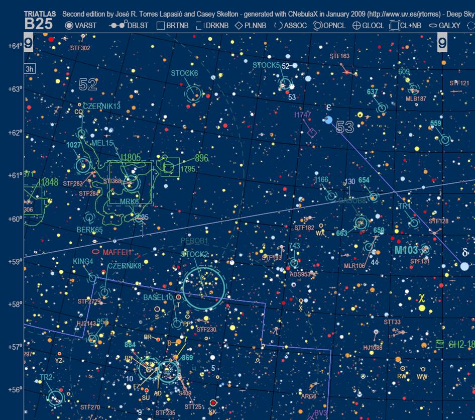
The working horse in the TriAtlas is the B-set, with a
linear scale very similar to the Sky Atlas 2000 deluxe but with much more
accuracy, stars and deep sky objects. It makes the location of object extremely
easy, and at the same time the scale and constellation lines helps a lot to
relate the sky with the maps. This set is my personal favorite as master sky
atlas.
A chart set (A4 for European and other ISO users, and Letter
8x11" for
Finally, the A-set has two purposes: to act as an
index for B and C sets, and to display the brightest and best deep sky objects.
This is similar to a 7-mag star atlas but reaching nine magnitude. This makes
it more useful and it allows locating many bright objects without the
cooperation of the other sets.
![]() Download the TriAtlas
second edition!!!
Download the TriAtlas
second edition!!!
NOTE: All links have been updated, contact us if
there is any problem
|
|
A4 (ISO) page size |
|
|
A-SET GENERAL INDEX Section A includes a selection of the best deep
sky objects and it is very handy to plan quick deep sky sessions and as a
general reference to swap to either B- or C-maps. 25 charts showing 9 mag stars Size:
47º x 67º portrait
layaout, monochrome Pointers
to B- and C- maps |
Links to download A-SET (A4 page size, ISO): |
|
|
● A-SET 2nd
edition: 25 charts to 9 mag |
||
|
B-SET STANDARD ATLAS Section B includes many thousands of deep sky
objects and is an atlas similar to Uranometria
2000. It can be used in combination with set A and the two key charts as a
standard-alone atlas. 107
charts showing 11 mag stars Size:
21º x 30º portrait
layaout, monochrome Pointers
to C- maps and back pointers to A maps |
Links to download B-SET (A4 page size, ISO): |
|
|
● B-SET 2nd edition: charts 1-36 ● B-SET 2nd edition: charts 37-72 ● B-SET 2nd edition: charts 73-107 |
||
|
C-SET DETAILED ATLAS Section C is the equivalent to Millennium Star
Atlas, although with many more deep sky objects. Use it to find the hardest
objects or in very crowded fields. 571 charts showing 12.6 mag stars Size:
8º x 12º portrait
layaout, monochrome Back
pointers to B- and A-maps |
Links to download C-SET (A4 page size, ISO): |
|
|
|
|
|
|
|
||
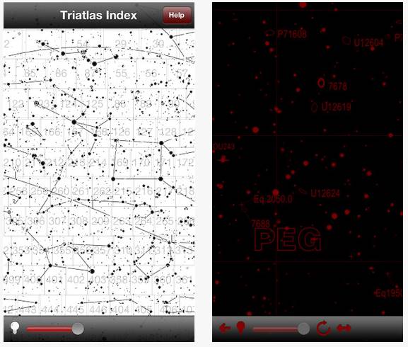
TriAtlas C for iPad and iPhone
Norbert Schimdt, a German programmer, developed an application initially for iPhone and later for iPad to make the C-set available in these devices. We granted him permission as far the application was free (as the atlas is and has to be). He has built an excellent application that makes the use of the atlas in the field a truly joy. It is relatively modest in size (400 Mb), navigable (passing charts with the neighboring charts border tags and also through an index chart), red color with controllable brightness (or white background), compact and quick to use. The link to the apple store can be found here. He developed it under the premise that it it would be free for everybody, and we stand here our wish it has to be free and altruist as the TriAtlas itself.
|
|
|
|


A look to the (obsolete) first release (June 2007)
This is the way I printed the PDF charts, in a single-volume book with the most comprehensive sky atlas available. I prepared
mine including all sets (A, B and C charts) before summer 2007 holidays, and I
was using it in three different telescopes during all the summer, with an
extraordinary performance. It allowed locating with accuracy many thousands
deep sky objects, and it was an invaluable help for catching objects at the
threshold, stellar planetary nebulae, etc. You just couldn't miss objects
because you didn't know exactly where to fix your attention at the eyepiece
field, or because there were too few stars to spot the place. In addition, the
collection of objects was very comprehensive. No other printed atlas plotted
more objects (well ...except the second edition!!!).

The TriAtlas included navigating aids to jump to the neighboring charts sets at higher magnifications. The chart number was at the lower right area (large outline font). Each chart included nine navigating points giving the chart number of the nearest neighboring charts within the same set, indicated in a bold font in the borders (the corners and in the middle sides). There were also smaller outline numbers in the A-charts indicating the location of the included B- and C- charts, and similar numbers in the B-charts to jump to the C-charts. It was very easy to move around a given area, even at high magnification, and swap between sets. Constellation lines were marked in all sets to make the identification in the sky even easier.

If one preferred a comfortable field atlas
instead, he/she only needed to print sections A and B (around 120 A4 pages). I
prepared mine like in the picture, protecting the pages of moisture with in a
folder with plastic sheets. The B-set had a scale similar to Sky Atlas 2000
deluxe edition, but with much more stars and objects. Other people printed the
atlas in A3 or similar formats. The maps were vector-based and could be
enlarged without losses in resolution.
The charts were large PDF files (=save
them to disk before opening). Good output were obtained
printing them with no shrinkage at 600 or more DPI (I generated my own charts
sending them directly to the printer for a best quality, and PDF charts were
not so perfect).
At that state the atlas was still unrefined, with overlapped
labels and objects, but nevertheless a very nice work.