[<][<=][=>]Index of this webpage
**++Climatology from Satellites Group++**
**++Postgraduate++**
++Current Research Assistants (and Doctorate Students):++
++Doctorate on Remote Sensing Students:++
++Master Postgraduate:++
++Master Students:++
++Advanced Undergraduate:++
++Practicum - Practical Training:++
++Current External:++
++Past ..., but very close to us ...:++
**++Publications++**
**++Links to Significant Meetings++**
''**++2015++**''
''**++2014++**''
**++Active Collaborations++**
**++Acknowledgments**++
**++Book suggestions++**
**++Link of the Day++** (in reality, ... every now and then)
2013
December
**++Teaching Subjects++**
Postgraduate Course on ''New Observation and Watching Systems in Meteorology and Climatology''
**Some Teaching Publications**
**++Research Lines++**
**''I Validation of low spatial resolution remote sensing data and products (GERB, SMOS, EPS/MetOp, SMAP)''**
**''II Radiative balance studies (GERB, CERES, SEVIRI, EarthCARE)''**
**''III Soil moisture from passive microwaves (SMOS)''**
**++Valencia & Alacant Anchor Stations++**
**What is an ''ANCHOR STATION''**? (from Professor H.-J. Bolle)/
**Rationale**/
**Desirable measurements at ''Anchor Stations''**/
How Representative are the ''Alacant and the Valencia Anchor Stations'' Measurements of their Respective Surrounding Meteorology?
Proposal for a ''Water Cycle Observatory'': The VALENCIA and the ALACANT ANCHOR STATIONS, Meteorological Reference Stations for Remote Sensing Data and Products
**Publications**
2008
2007
2006
2005
2003
2002
**++Involvement in Satellite Earth Observation Missions++**
**SMOS (''Soil Moisture and Ocean Salinity'')**/
**SMOS Validation Rehearsal Campaign Activities at the Valencia Anchor Station**
**Scientific Team**
**Purpose**
**Activities
**SM Measurements**
**Vegetation Measurements**
**Soil texture**
**Airborne Operations during the SMOS Validation Rehearsal Campaign (Tauriainen, 2008)**
**Modelling**
**Publications**
2011
2010
2008
2007
2006
2005
2004
2003
2002
**Projects**
**EarthCARE (''Earth Clouds, Aerosols and Radiation Explorer'')**
**Publications**
2012
2011
2007
2006
2004
2003
2002
2001
**Projects**
**GERB (''Geostationary Earth Radiation Budget'')**/
**Publications**
2011
2008
2007
2006
2005
2004
2000
**Projects**
**CERES (''Clouds and the Earth's Radiant Energy System'')**/
**Publications**
2012
2008
2007
2006
2005
2004
2000
**Projects**
**EPS/MetOp (''EUMETSAT Polar System / MetOp'')**/
**Publications**
**Projects**
**++Other Significant Research Projects and Contracts++**
**Publications**
**++Field Campaigns++**
**++Supervision of Research Academic Work++**
**++Selected Significant Publications++**
**++Photographic Album: A Sample++**/
2014
2013
2012
2008
2007
2006
2005
2004
2003
2002
2001
2000
1988
[<][<=][=>][*]
**EarthCARE (''Earth Clouds, Aerosols and Radiation Explorer'')**
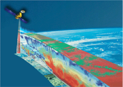
Artist Image of EarthCARE
Publications
2012
� Domenech C., E. Lopez-Baeza, D. P. Donovan and T. Wehr (2012): Radiative Flux Estimation from BBR using Synthetic Angular Models in the EarthCARE Mission framework. Part II: Evaluation Journal of Applied Meteorology and Climatology, 2012. [under review]
2011
� Domenech, C., E. Lopez-Baeza, David P. Donovan, Tobias Wehr (2011): Radiative Flux Estimation from a Broadband Radiometer Using Synthetic Angular Models in the EarthCARE Mission Framework. Part I: Methodology. Journal of Applied Meteorology and Climatololy, 50, 974�993 (2011) doi: http://dx.doi.org/10.1175/2010JAMC2526.1
2007
� E. Lopez-Baeza, C. Dom�nech Garc�a, A. Velazquez Blazquez, H.W. Barker, F.H. Berger, A. Lorenz, M. Viollier, M. Capderou, P. Raberanto, D. Donovan, M. Bouvet (2007): Improvement of Angular Dependence Models for the Broadband Radiometer Onboard the ESA EarthCARE Mission. The EarthCARE Workshop. ESA-ESTEC, Noordwijk, The Netherlands, 7-9 May 2007
� C. Domenech, D. P. Donovan, H. W. Barker, M. Bouvet, E. Lopez-Baeza (2007): Synergy between active and passive sensors for improving retrieval algorithms. The EarthCARE Workshop. ESA-ESTEC, Noordwijk, The Netherlands, 7-9 May 2007
� E. Lopez-Baeza, Cano, A.; Domenech, C.; Estelles, V.; Ferreira, A.G.; Narbon, C.; Sanchis, J.; Velazquez, A.; Vidal, S.; Smith, G.L.; Szewczyk, Z.P.; Labajo, A.; Alonso, S.; Harries, J.E.; Russell, J.E.; Clerbaux, N.; Dewitte, S.; Rius, T.;Torrobella, J.; Pino, D.; Sanchez, J.J.; Tarruella, R. (2207): Validation of broadband radiation balance products at the Valencia and the Alacant Anchor Stations. GERB/CERES Ground Validation Campaigns. The EarthCARE Workshop. ESA-ESTEC, Noordwijk, The Netherlands, 7-9 May 2007
� Domenech, C., Donovan, D.P., Barker, H.W., Bouvet, M., Lopez-Baeza, E. (2007): Improvement of Broadband Radiance to Flux Conversion by Using the Synergy Between Active and Passive Remote Sensing Instruments. SPIE Europe Remote Sensing 2007, Florence, Italy, 17 - 20 September 2007
2006
� Lopez-Baeza, E., C. Domenech, H. W. Barker, M. Bouvet, D. Donovan, A. Velazquez (2006): The ESA EarthCARE Mission. Development of 3 along-track views angular dependence models for improved radiance to flux conversion. 2nd International Symposium Recent Advances in Quantitative Remote Sensing Torrent (Valencia), Spain, 25-29 September 2006 (Oral Presentation)
� Lopez-Baeza, E.; Domenech, C.; Barker, H.W.; Bouvet, M.; Donovan, D.; Velazquez, A. (2006): Development of an extense atmospheric scene database with the 3-D Monte-Carlo EarthCARE Simulator to build 3 along-track views angular dependence models in the framework of ESA EarthCARE Mission. Committee on Space Research 36th COSPAR Scientific Assembly. Scientificc Commission A1.1 Atmospheric Remote Sensing: Surface Layer, Troposphere, Stratosphere and Mesosphere. Beijing, China, 16 � 23 July 2006
� Domenech, C., E. L�pez-Baeza (2006): Development of broadband BRDFs from TOA CERES radiances corresponding to large footprints at a global scale. 2nd International Symposium Recent Advances in Quantitative Remote Sensing Torrent (Valencia), Spain, 25-29 September 2006 (Poster Presentation)
� Domenech, C., E. L�pez-Baeza (2006): Obtention and classification of broadband low spatial resolution BRDFs from TOA CERES radiances. Committee on Space Research 36th COSPAR Scientific Assembly. Scientificc Commission A3.1 Terrestrial phenomena and land products from space: validation, application and perspectives. Beijing, China, 16 � 23 July 2006
� Domenech, C., E. L�pez-Baeza (2006): Obtenci�n y Clasificaci�n de BRDFs de Banda Ancha en Baja Resoluci�n Espacial a partir de Radiancias CERES en Techo de la Atm�sfera [Broadband and Low Spatial Resolution BRDFs Retrieval from CERES Top of Atmosphere Radiances]. 5th Asamblea Hispano Portuguesa de Geodesia y Geof�sica, Universidad de Sevilla, Spain, 30 Jan. - 3 Feb. 2006
2004
� ESA 2004. Mission Experts Division. Scientific Co-ordinator: P. Ingmann. Members of EarthCARE Mission Advisory Group (2004): EarthCARE - Earth Clouds, Aerosols and Radiation Explorer . REPORTS FOR MISSION SELECTION. THE SIX CANDIDATE EARTH EXPLORER MISSIONS. ESA SP-1279(1). April 2004. ESA Publications Division, c/o ESTEC, Noordwijk, The Netherlands, Editor: B. Battrick. ISBN 92-9092-962-6. ISSN 0379-6566
2003
� Bodas-Salcedo, A., Lopez-Baeza, E., Smith, G.L. (2003): A flux retrieval error behavior with CERES/TRMM data. Remote Sensing of Clouds and the Atmosphere VII. Edited by Schaefer, Klaus P.; Lado-Bordowsky, Olga; Comeron, Adolfo; Picard, Richard H. Proc. of the SPIE, Volume 4882, pp. 1-12 (2003)
� Bodas Salcedo, A., J. F. Gimeno Ferrer and E. L�pez Baeza (2003): Flux retrieval optimisation with an along-track broad-band radiometer. Journal of Geophysical Research, Vol. 108 No. D2, 2003
2002
� R. Kandel, A. Bodas Salcedo, J.F. Gimeno Ferrer, and E. L�pez-Baeza (2002): Broad-Band Radiometry for EarthCARE. Proc. EarthCARE Workshop (Second international workshop on space-borne cloud profiling radar). CRL/ARS Report02-02, 133-136, TRITON SQUARE, Tokyo, Japan, 17-18 July 2002
� A. Bodas Salcedo, J. F. Gimeno Ferrer, and E. L�pez-Baeza (2002): BBR Radiance to Flux Inversion Analysis. Proc. EarthCARE Workshop 137-143, TRITON SQUARE, Tokyo, Japan, 17-18 July 2002
� A. Bodas Salcedo, J.F. Gimeno Ferrer, E. L�pez Baeza, and J. P. V. Poiares Baptista (2002): Study of the Radiance to Flux Inversion within the Framework of the EarthCARE Mission. Poster Recent Advances in Quantitative Remote Sensing, Torrente (Valencia), 16-20 September 2002
� A. Bodas Salcedo, J.F. Gimeno Ferrer y E. Lopez Baeza (2002): Optimizaci�n de un Radi�metro de Banda Ancha en el Marco de la Futura Misi�n EarthCARE. El Agua y el Clima - L'Aigua i el Clima, Jos� A. Guijarro Pastor, Miquel Grimalt Gelabert, Mercedes Laita Ruiz de As�a y Sergio Alonso Oroza (Eds.). Publicaciones de la Asociaci�n Espa�ola de Climatolog�a (AEC), 2002, Serie A, n� 3, pag. 375-385, Planogr�fica Balear, Marratx� (Mallorca), xii+594 pp
2001
� ESA 2001: Members of EarthCARE Mission Advisory Group (2001): The five candidate Earth Explorer Core Missions � EarthCARE � Earth Clouds, Aerosols, and Radiation Explorer. ESA SP-1257(1)
Projects
Postgraduate Students: Carlos Domenech and Almudena Velazquez
Improvement of Angular Dependence Models
Contract ESTEC-ESA (Dec. 2003 � Dec. 2005)
- Partners:
University of Valencia (Coordination Institution)
Laboratoire de Meteorologie Dynamique du CNRS (France)
Meteorological Service of Canada
Technische Universitat Dresden (Germany)
- P.I.: E. Lopez-Baeza (Coordinator)
- ESA Scientific Coordinator: Dr Marc Bouvet
- Objectives of the Study Project
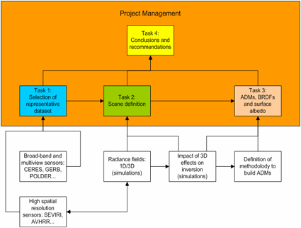
1) to develop improved ADMs from instantaneous flux retrieval, specially for broad-band radiometers with a footprint in the order of around 10km and multi-view capability and
2) to evaluate the impact of three-dimensional radiative effects on the accuracy of the derived TOA fluxes
- Overall structure of the Study Plan
The work was planned by a close interaction between experimental and theoretical results.
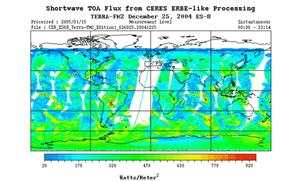
The first task was devoted to the construction of a database from satellite data. The best current source has been the instrument CERES/Terra with its along-track capabilities, once a true along-track (trueAT) scan was implemented attempting to rectify the original configuration which did not take into account the Earth rotation, causing the RAA to be kept constant at 90 degrees. As a consequence of that, there was originally a several footprints distance between a forward and backward sweep even for relatively small (<60 degrees) VZAs. The Study Team proposed the CERES Science Team to introduce a variable trueAT angle as a function of a satellite groundtrack latitude, seeking to minimize the width of an AT swath within VZAs of less than 60 degrees. This correction is now operational in the CERES system.
True CERES along-track scan over the Valencia Anchor Station
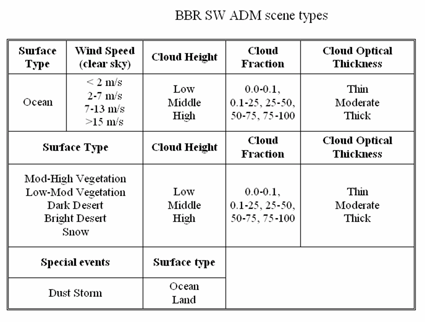
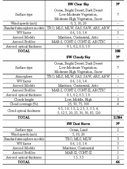
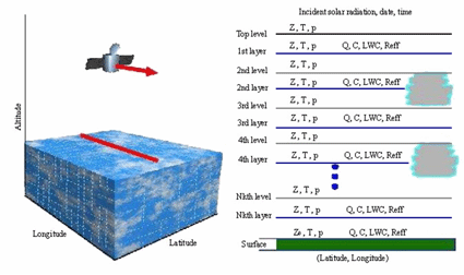
The second task defined the scenes upon which the angular models were constructed. The total number of simulated scenes is larger than 200.000, building up significant ensembles with a robust statistical analysis, and including realistic 3D effects. This figure is really huge although it is a minimum number to be able to develop ADMs at a global scale, as EarthCARE will do. The scene definition includes realistic atmospheric situations, considering their spatial and temporal variability as well, defined according to latitude and geometrical observation conditions for a sunsynchronous EarthCARE orbit with Equator crossing time between 13:30 and 14:00 LST on a descending node.ADM Scene Definition (SW)
ADM Scene Database (SW)
No. of subscenes x geometrical cases [ f(orbital constrain) ] = 214.396 simulations
2.868 Clear-sky ADMs
210.600 Cloud ADMs
918 Dust Storm ADMs
Simulations carried out in the EarthCARE Simulator, a 3D Monte-Carlo photon transport algorithm for shortwave and longwave that includes multiscattering
(Donovan, D. P., Schutgens, N., Baptista, J.-P. V., Barker, H., Blanchet, J.-P., Belaulne, A., Symeyer, W., Quante, M., Schimmer, I., Macke, A., Testud, J., Kato, S., Cole, J., 2004. The EarthCARE Simulator. Users Guide and Final Report. KNMI, ESA/ESTEC, MSC, UQAM, GKSS, U. of Kiel, CETP-UVSQ and Penn. State U.)/
Computational Interface Systems
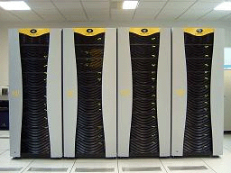
University of Valencia SGI Altix 3700 Computing System, 72 processors and 160GB central memory
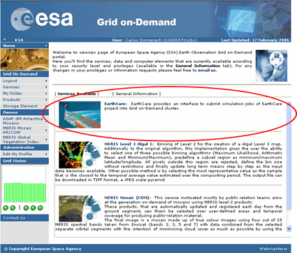
European Space Agency (ESA) Grid on-Demand Services and Infrastructure (GODIS) for Earth Observation Applications. See also http://eogrid.esrin.esa.int/news/fullproject.asp?id=17
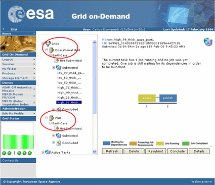
ESA Grid On-Demand CNR (Consiglio Nazionale delle Ricerche) associated cluster
Broadband Radiometer Optimization Study
Contract ESTEC n�14685/00/NL/JSC through REOSC SAGEM (France) (Oct. 2000 - Jul. 2001). P.I. (sub-contract): E. Lopez-Baeza
Study of the Flux Retrieval Error Behaviour.
Validation Using Real CERES/TRMM Data
Shortwave (SW)(Simulations)
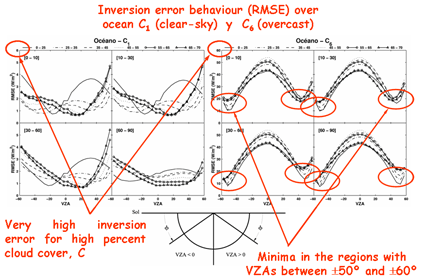
SW RMSE inversion error as a function of the viewing zenith angle (VZA), as obtained from radiative transfer simulations, for ocean and for two different cloud cover intervals, namely clear sky (left) and overcast (right)
The four graphs within each figure correspond to different relative azimuth intervals as indicated in the square brackets
The different curves correspond to different solar zenith angles (SZA) as indicated in the legend
Note the different scaling of the axes
Shortwave (SW)(CERES/TRMM Data)
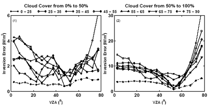
Study of the Flux Retrieval Error Behaviour using real CERES/TRMM Data
SW flux retrieval error as function of the VZA, using only one azimuthal bin
Cloud cover intervals range from 0 to 50% (left), and from 50 to 100% (right)
Different lines correspond to different solar zenith angle bins
Longwave (LW)
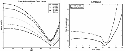
Left: LW RMSE inversion error as a function of the VZA, as obtained from radiative transfer simulations. The results correspond to any surface type (ocean, land, vegetation) for six different cloud cover values
Right: LW flux retrieval error as function of the viewing zenith angle for two cloud cover intervals, from 0 to 50%, and from 50 to 100%, from real CERES/TRM data
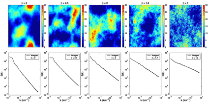
Generation of Realistic Synthetic Cloud Images to Study the Influence of the Spatial Structure of the Scene
The size of the cloud fields are 512 x 512 km2. The resolution is 500 m (~ size of the Multispectral Imager, MSI, also onboard the EarthCARE Platform)
See Alejandro Bodas' Doctoral Thesis: Optimizaci�n de un Radi�metro de Banda Ancha en el Marco de la Misi�n EarthCARE (ESA). Estudio del Proceso de Inversi�n de Radiancias a Flujos. Universitat de Val�ncia, Facultat de F�sica, 2003 (In Spanish)


