.svg)


Artificial Intelligence techniques and big data offer the first global maps of key features of vegetation
- Fundació Parc Científic
- February 4th, 2019
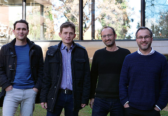
De izquierda a derecha, Álvaro Moreno, Javier García Haro, Gustau Camps-Valls, Manuel Campos-Taberner
Researchers from the University of Valencia have developed the first global maps of phosphorus and nitrogen content in vegetation, as well as in the efficiency of the use of water, with Artificial Intelligence and Big data techniques. The application of these maps is expected to have a huge impact on other fields like biodiversity, agriculture or the adaptation of species to climate change.
Artificial intelligence (AI) techniques, together with the support of Google to work with massive data of Earth satellite observation, have allowed to create the first global maps of vegetation variables that were only available locally until now.
A group of researchers from the Image Processing Lab (IPL), at the Parc Científic, and from the Environment Remote Sensing Group (ERS), from Department of Earth Physics and Thermodynamic, both at the University of Valencia, have developed a methodology to generate global maps with parameters, variables and key features of the vegetation of the planet. This technology, based on artificial intelligence, works in the Google Cloud to make use of images from the NASA and the ESA, enabling the generation and the monitoring of vegetation at high spatial and temporal resolution globally. The research has shown very interesting patterns in key parameters to analyse climate change, as for example phosphorus content, nitrogen and leafiness of the plants.
‘Until now it was impossible to make those maps because we didn’t meet the requirements. We didn’t have powerful and thorough machine learning statistical tools; we didn’t have access to big data sets or to cloud computing to deal with the satellite images petabytes in a fast and careful way. Now, with the Google platform and the Artificial Intelligence algorithms, we can calculate with data from the ESA and the NASA quickly and worldwide’ says Álvaro Moreno, physicist and electronic engineer and leader of the investigations, as well as current investigator of the IPL in the group Image and Signal Processing (ISP).
The researchers have carried out the processing of data in the Google Cloud. ‘The mathematical techniques are machine learning models that learn the relation between the images the satellites acquire and the measures in the surface of the Earth. Once they have learnt this relation for many observation-mesure pairs, this knowledge can be extrapolated to any other location and time to generate measure of interest estimation maps’ says Manuel Campos-Taberner, ERS researcher. ‘There are many possibilities and now we can generate global maps of almost any variable of interest in which there is in situ data, since our satellites are orbiting and giving great temporal and spatial observations. In our case, we have generated global maps of biophysical parameters that are useful to monitor vegetation (how much vegetation we have, to what extent it is active and what are the sections of phosphorus and nitrogen), but it could also be used for other variables of interest, not only on earth but also in water and even in air quality’ he adds.
For more than 15 years, the team has taken part in similar initiatives with the European Organisation for the Exploitation of Meteorological Satellites (EUMETSAT) for the exploitation of data of current and future missions inside an European program called LSA-SAF (The Satellite Application Facility where Land Surface Analysis). ‘This is the first European initiative aimed at producing and distributing variables of the state of the terrestrial environmental system in real time. It offers great value products for climate and environment observation’ says Javier García Haro, principal researcher of the ERS group’s LSA-SAF project.
Future applications
According to scientists, the new maps will have implications in other fields, as for example in precision agriculture, biodiversity or the adaptation of species to climate change. ‘The research is not only a conceptual test of what can be achieved by combining machine learning and remote sensing, but it also opens the door to future scientific studies that exploit these type of maps’ says Gustau Camps-Valls, Electronic Engineering Professor and IPL researcher, with the help of an ERC Consolidator Grant for the progress of Artificial Intelligence for Earth observation. ‘The applications and implications are endless, even more with the current pressure over, for example, food production and biofuel, without neglecting the impact over ecosystems and the adaptation of species’ he concludes.
This Valencian research team has developed this methodology with the collaboration of researchers from more than 20 institutions all over the world (Max Planck, UCL, Univ. Montana, Univ. California, etc.), with the collaboration of Google ‘Google Earth Engine’ and data from multispectral sensors from NASA over the last 20 years. Steven W Running (University of Montana), lead author of the 4.º Evaluation Report of the Intergovernmental Panel over Climate Change (IPCC), which made him worthy of a Peace Nobel Prize (2007), has participated in this research. ‘The work of Álvaro Moreno and his collaborators is amazing’ he says, ‘now, with a computer with access to Internet you can make things the ESA or the NASA have never done in 50 years’.
A methodology to derive global maps of leaf traits using remote sensing and climate data
Moreno-Martinez, A. and Camps-Valls, G. and Kattge, J. and Robinson, N. and Reichstein, M. and van Bodegom, P. and Kramer, K. and Cornelissen, J.H.C. and Reich, P. and Bahn, M. and Niinemets, U. and Penuelas, J. and Craine, J.M. and Cerabolini, B.E.L. and Minden, V. and Laughlin, D.C. and Sack, L. and Allred, B. and Baraloto, C. and Byun, C. and Soudzilovskaia, N.A. and Running, S.W. Remote Sensing of Environment 218 (12) :69-88, 2018
Global estimation of biophysical variables from Google Earth Engine platform
Campos-Taberner, M. and Moreno-Martinez, A. and Garcia-Haro, F. J. and Camps-Valls, G. and Robinson, N. P. and Kattge, J. and Running, S.W. Remote Sensing (10) :1167, 2018
Regional Crop Gross Primary Productivity and Yield Estimation Using Fused Landsat-MODIS Data
Mingzhu He, John S. Kimball, Marco P. Maneta, Bruce D. Maxwell, Alvaro Moreno, Santiago Beguería and Xiaocui Wu. Remote Sens. 2018, 10(3), 372; https://doi.org/10.3390/rs10030372
Categories: Ciencias de la Tierra y el Espacio , Física , Ciencias Tecnológicas
Other News