[<][<=][=>]Index of this webpage
**++Climatology from Satellites Group++**
**++Postgraduate++**
++Current Research Assistants (and Doctorate Students):++
++Doctorate on Remote Sensing Students:++
++Master Postgraduate:++
++Master Students:++
++Advanced Undergraduate:++
++Practicum - Practical Training:++
++Current External:++
++Past ..., but very close to us ...:++
**++Publications++**
**++Links to Significant Meetings++**
''**++2015++**''
''**++2014++**''
**++Active Collaborations++**
**++Acknowledgments**++
**++Book suggestions++**
**++Link of the Day++** (in reality, ... every now and then)
2013
December
**++Teaching Subjects++**
Postgraduate Course on ''New Observation and Watching Systems in Meteorology and Climatology''
**Some Teaching Publications**
**++Research Lines++**
**''I Validation of low spatial resolution remote sensing data and products (GERB, SMOS, EPS/MetOp, SMAP)''**
**''II Radiative balance studies (GERB, CERES, SEVIRI, EarthCARE)''**
**''III Soil moisture from passive microwaves (SMOS)''**
**++Valencia & Alacant Anchor Stations++**
**What is an ''ANCHOR STATION''**? (from Professor H.-J. Bolle)/
**Rationale**/
**Desirable measurements at ''Anchor Stations''**/
How Representative are the ''Alacant and the Valencia Anchor Stations'' Measurements of their Respective Surrounding Meteorology?
Proposal for a ''Water Cycle Observatory'': The VALENCIA and the ALACANT ANCHOR STATIONS, Meteorological Reference Stations for Remote Sensing Data and Products
**Publications**
2008
2007
2006
2005
2003
2002
**++Involvement in Satellite Earth Observation Missions++**
**SMOS (''Soil Moisture and Ocean Salinity'')**/
**SMOS Validation Rehearsal Campaign Activities at the Valencia Anchor Station**
**Scientific Team**
**Purpose**
**Activities
**SM Measurements**
**Vegetation Measurements**
**Soil texture**
**Airborne Operations during the SMOS Validation Rehearsal Campaign (Tauriainen, 2008)**
**Modelling**
**Publications**
2011
2010
2008
2007
2006
2005
2004
2003
2002
**Projects**
**EarthCARE (''Earth Clouds, Aerosols and Radiation Explorer'')**
**Publications**
2012
2011
2007
2006
2004
2003
2002
2001
**Projects**
**GERB (''Geostationary Earth Radiation Budget'')**/
**Publications**
2011
2008
2007
2006
2005
2004
2000
**Projects**
**CERES (''Clouds and the Earth's Radiant Energy System'')**/
**Publications**
2012
2008
2007
2006
2005
2004
2000
**Projects**
**EPS/MetOp (''EUMETSAT Polar System / MetOp'')**/
**Publications**
**Projects**
**++Other Significant Research Projects and Contracts++**
**Publications**
**++Field Campaigns++**
**++Supervision of Research Academic Work++**
**++Selected Significant Publications++**
**++Photographic Album: A Sample++**/
2014
2013
2012
2008
2007
2006
2005
2004
2003
2002
2001
2000
1988
[<][<=][=>][*]
**Activities
Ground Measurements during aircraft operations
Objectives:
(i) To measure soil moisture content for the whole 10 x 10 km2 under saturation conditions, i. e., after a significant rain event, and during the soil drying period, i.e., 24, 48 h, 5-7 days, 10-15 days, after precipitation
(ii) To measure SM of each significant and representative hydro-physiological unit:
� Compare different SM measurements within each unit
� Compare different SM measurements in polygones within each
� Compare SM measurements of similar units
� Compare SM measurements of different units
(iii) Establish relationships to unify / fragment units or re-assign polygons in different units
(iv) Provide the approximate average for each unit and for all the units in total within the 10 x 10 km2
(v) Compare SM from the units to that of the total area
(vi) Study the representativity of the automatic SM stations in the whole 10 x 10 km2 area, using the large number of measurements for eachy day of the campaign
(vii) Establish a quick and efficacious methodology to est�mate SM of a large area out of a few measurements, as preparation for Cal/Val
(viii) Compare SM under humid and dry conditions; establish the spatial and temporal dynamics of SM
The campaign at the Valencia Anchor Station Site will begin on 19th April. The first possible campaign flight should be performed before sunrise on 20th April, independently of weather conditions, except if it is actually raining.
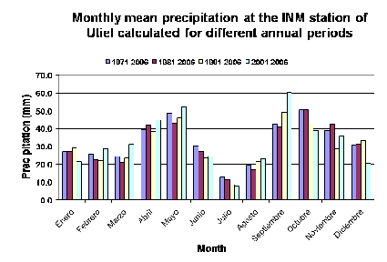
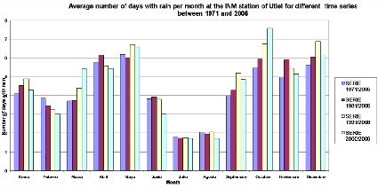
The area will be crossed diagonally (SE to NW) and along 5 separate North/Southbound parallel lines displaced by 2 km relative to each other.
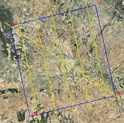
Valencia Anchor Station study area with the five flight lines and the diagonal flight line all geo-referenced over an orthophoto of the study area
SM Measurements
Volumetric/Gravimetric soil samples Volumetric probe measurements (Theta Probe)
In each sampling plot, volumetric SM data will be obtained by means of capacitance probes (Delta-T Theta probes) calibrated according to the soil textures obtained in each case and, in parallel, soil samples will be obtained in cylinders of known volumen where volumetric soil moisture will be measured, thus obtaining soil bulk density. From that, soil porosity will be estimated because this parameter is responsible of the soil water retention capacity.
The percent of water in volume obtained will be used as �ground truth� with respect to the SM values obtained with the capacitance probes.
The ground measurements will consist of 20 teams distributed throughout the entire area, (4 teams for the detailed diagonal flight, 4 teams for the harder soil shrub area (left-hand side of the image, teams 5, 6, 7, 8), and 3 teams for the rest of each flight line remaining. Depending on the soil properties and hardiness each group will take a large number of cylinder volumetric samples and an average of 1000 volumetric probe measurements every flight day.
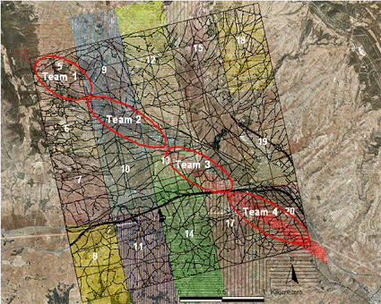
Flight lines over the 10 x 10 km2 area
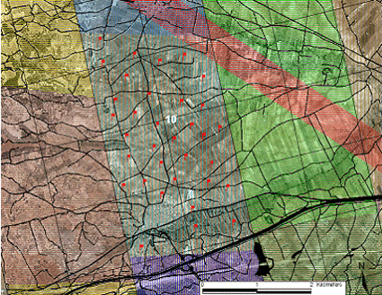
Detail of the sampling to be carried out by one of the teams (team #10, just an example)
One team more will perform sea surface measurements, for calibration purposes of the radiometers onboard the research aircraft, and according to the Spanish Port System (Puertos del Estado)(tbc)
Vegetation Measurements
From our detailed vegetation map (generated at 1:2000 scale), vegetation over the 10 x 10 km2 area shows a scarce diversity of vegetation species. Within the area, the major vegetation uses are vineyard, almond- and olive-trees, coniferous forests, matorral shrubs (Thymus vulgaris, Rosmarinus officinalis, Quercus coccifera, Genista scorpius, Ulex parviflorus, Ramnus licioides, Stipa tenacissima, Juniperus communis), and very very scarce areas of cereals (Zea mays and Avena sativa).
Vegetation parameter sampling is not needed to be too intensive. However, accurate estimation of vegetation stage should be achieved through simple measurements over well chosen areas:
� Vegetation height
� Phenologic stage (number of leaves in vineyards/plant, etc) in some fields
� Digital photographs giving general information on the phenology (in orchards)
� LAI measurements in shrubs and matorral areas
� Alometric parameter sampling in tree areas to relate plant dimensions to vegetation characteristics which are required as inputs for the retrieval models
� Vegetation water content sampling
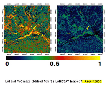
LAI and FVC maps over the area (August 2006, courtesy of EOLAB)
For each of the dominant vegetation types, the sampling to be performed will consist of: branches and leaves of almond, olive, Holm Oak and pine trees, and complete individuals of shrubs. In these samples we will measure all the dimensional parameters and laboratory analysis to estimate biomass.
Soil texture
Soil samples on measured plots will be taken before the campaign to begin laboratory analysis and probe texture calibrations. Each team will measure a statistically significant amount of point measurements in plots distributed throughout the selected area. Of these plots, soil bulk density, percentage of organic material, texture and probe calibration analysis will be determined.

