

Its address is Entrada camí dels Rochs n. 11, in the city of València. It can be accessed from the Carrera d’en Corts.
Second half of the 19th century or beginning of the 20th century.
As explained in the 2018 Pla d’Acció Territorial de Protecció de l’Horta de València de l’any (Territorial Action Plan for the Protection of the irrigated land de València), like many other popular constructions in l’Horta (the irrigated land) of Val`rncia, it is not at all easy to give the barraca (hut) Blaio Navarro t its own individual chronology and history. Due to its simple constructive structure, it can usually be dated back to the second half of the 19th century or the beginning of the 20th century, even with possible important modifications at some point because it was necessary to rebuild it due to the ageing of the materials or because it was affected by the floods of the Túria River in 1949 and 1957. These barraques (huts) do not usually appear in the documents of previous centuries with identifiable names or place names, while they were usually known orally in their surroundings by the name or nickname of the people who owned or lived there. For this reason, the name of the barraca was frequently modified due to the change of residence of these people, and it is not known since when it has been known by the current name of Blaio Navarro.
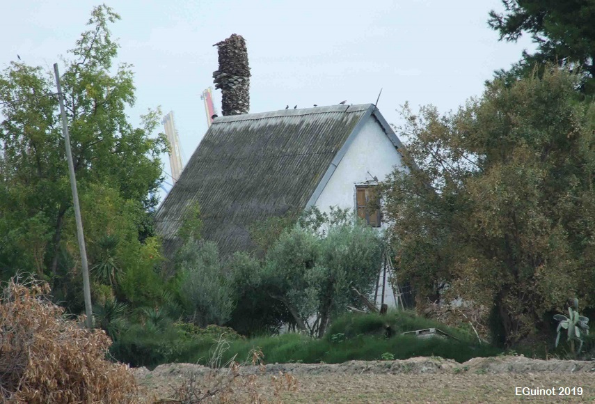
According to the Catàleg de béns i espais protegits de Naturalesa Rural de la Revisió Simplificada del Pla General d’Ordenació Urbana de València (2013) (Catalogue of protected assets and spaces of Rural Nature of the Simplified Revision of the General Urban Development Plan of València), Blaio Navarro's barraca (hut) is today isolated on the plot, along with small annexes of no interest that are used as warehouses. The barraca maintains its structure, with a floor plan of about 11 metres (36ft 1 in) deep by 6,60 metres (21ft 7.8 in) wide and preserves the façade composition with the original door and window openings. J. A. García Esparza estimates the surface area to be about 70 m2 (753.4737ft²). At this point in time (2019), it shows clear signs of abandonment, with dead palm trees beside it and, as in almost all the barraques (huts), the roof which used to be made vegetation with green elements has been replaced by a corrugated iron roof, to which solar panels have been added.
- Pla d’Acció Territorial de Protecció de l’Horta de València. Catàleg de Proteccions, Fitxes dels elements catalogats de Primer Orde, EPA_15.04, pp. 155-156.
- Pla General d’Ordenació Urbana de València (PGOU), revisió de l’any 2012.
- Direcció General de Patrimoni Cultural Valencià. Catàleg de patrimoni.
- Notícia de l’Agència EFE (4 de desembre del 2016) - Valencia concede por primera vez ayudas para rehabilitar el patrimonio rural.
GARCIA ESPARZA, J. A. (2012), Barracas del litoral Mediterráneo: catálogo de Valencia y su entorno, Castelló, Universitat Jaume I, pp. 104-105.
DEL REY. M. (2010), Arquitectura Rural Valenciana, Barcelona, Galerada (1ª edició: València, Direcció General de Patrimoni Artístic, 1996)
GARCIA ESPARZA, J. A. (2008), “La barraca Valenciana, procesos de transformación”, Revista valenciana d'etnologia, 3, pp. 145-159.
CRUZ OROZCO, J. (2003), “Las viviendas de cubierta vegetal en el territorio valenciano: el caso de la barraca”, Revista El Pajar: Cuaderno de Etnografía Canaria, 14, pp. 111-116.
RUIZ RUBIO, J. V. (1999), Construint una barraca valenciana, València, Ajuntament d’Alboraia-Col·legi d’Aparelladors i Arquitectes Tècnics de València-Col·legi d’Arquitectes de la Comunitat Valenciana.
SANCHIS GUARNER, M. (1957), Les barraques valencianes, Barcelona, Ed. Barcino. (reedició: València, Institució Alfons el Magnànim, 1999).
ALMELA VIVES, F. (1960), La vivienda rural valenciana, Valencia, La Semana Gráfica.
CASAS TORRES, J. M. (1944), La vivienda y los núcleos rurales de la huerta de Valencia, València, Diputació Provincial de València.


Photos: E. Guinot, Google Earth