
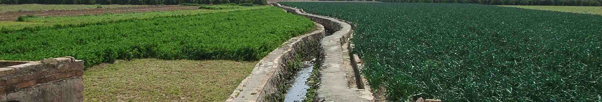
Irrigational canals are excavated in the ground and their main function is to conduct water from its point of capture to the places in which it will be used, such as fields and mills, among others. For the same reason, irrigation ditches are always built with a slight slope that allows water to circulate by gravity, without any complementary source of energy.
There are many irrigation canals in the Horta de València, but each and every one of them is part of a larger system, known by "hydraulic system". We have a total of eight in the Horta and all of them are well-known: the irrigation canals of Mestalla, Rascanya, Tormos, Rovella, Favara, Mislata and Quart-Benàger-Faitanar, which make up the Tribunal de les Aigües, plus the Royal Acequia of Montcada.
Each one of them consists of a main channel or "mother canal", a very old nomenclature already used in the 13th Century, in times of Jaume I, as well as a series of secondary branches that direct the water to towns or specific picnics, traditionally known by different names (branches, row, roll, etc.). They are also subdivided into new secondary irrigation canals as many times as necessary until they reach the individual canals where the water enters each of the crop fields. In the Horta de València, it is frequent that each one of these systems is transformed in its totality or partiality into an arborescent form when seen in a map.
Traditionally, the construction of irrigation canals was carried out by excavating a canal in the same land on which they passed, that is to say, their channel was the earth itself. The mortar was only used in delicate passageways, such as bridges, or in relevant places to split the water in two irrigation canals. It was not until the twentieth century that the lining of watercourses with walls of mortar began, which later became concrete. It should be remembered that this type of work has significantly altered the physiognomy of the irrigation canals, which lost their characteristic amplitude and the meandering of their course with the clods around them full of reeds.
Maps description
- Horta de València: map of the historical ditches and dams before the 'South Plan' (1973). In this 1956 map/picture, before the industrial and urban boom, we can see the still huge extension of vegetable gardens (about 15,000 ha). Today the extent is barely 5,000 hectares.
- Historical ditches in the central sector of the municipality of València.
- Historical network of ditches in the Ciutat Vella de València (ca. 19th century), with an altitude map and urban layout.
- In the district of Poblados Marítimos de València, irrigation ditches played an essential role in the road network, since their layout separated each neighborhood or historical sector: El Grao, Canyamelar, Cabañal, Cabo de Francia and Malvarrosa.