


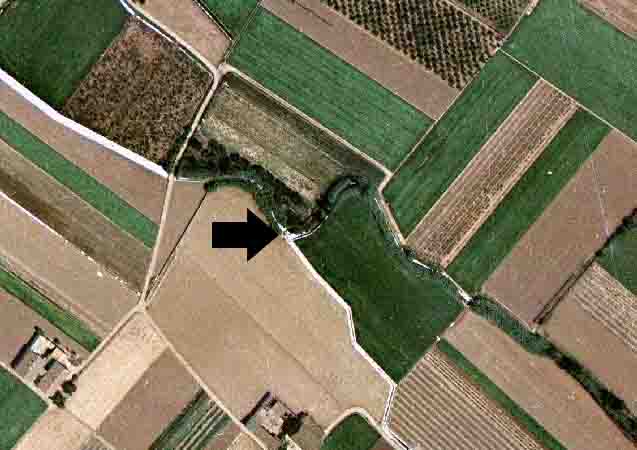
They are located in the El Palmar irrigation canal, in the northern part of the tramway depot on València's Ronda Nord, between Alboraia and the monastery of Sant Miquel dels Reis. It is possible to get there by the roundabout at the confluence of this northern ring road with the Avinguda d’Alfahuir, entering by the only asphalted road that gives access to the irrigated land.
The tongues of land maintain their traditional structure, although their entire surroundings have been completely transformed. In addition, they have been left half hidden by the construction of an underground channel that goes up to the Carraixet ravine to drain the torrential rains in the surrounding rural area.
14th-15th centuries
According to Guinot and Selma (2005), Selma (2014) and Mangue (2000), these tongues of land do not form part of the great irrigation canals organised in l’Horta of València (the irrigated land) since the Islamic Middle Ages or after the Christian conquest of the 13th century and the division of Jaume I (James I). In fact, the irrigation canals of Palmar and Vera were autonomous local irrigators until the middle of the 19th century when they were gradually, and sometimes in a conflictive manner, integrated into the Comunitat de Regants de la Séquia de Rascanya (Irrigation Community of the Rascanya irrigation canal). For example, in 1756 a lawsuit preserved in the Arxiu del Regne de València (Archives of the Kingdom of València), Government section, no. 4321, gives an account of Domingo Vicente's oath as the owner of the Rafalterràs irrigation canal, the old name of the rural area of the Alboraia-València district that corresponds exactly to this area. This organisational autonomy of past centuries is due to the fact that these irrigation canals are located in a valley between the Carraixet ravine and the districts of Orriols and Benimaclet. It was also an old marshy area and a lagoon area until medieval times. The space located to the east of the current V-21 or highway from Castelló to the sea. Therefore, they are extensions of the irrigated space already made by the Christian low-medieval society. Indeed, the water they had in the past centuries is not directly from the Túria River but surplus from the Montcada, Tormos and Rascanya irrigation canals, and also water from fountains, springs and tusks in their surroundings. Consequently, their organisation and irrigation infrastructures were smaller than in the case of the irrigation canals of the Tribunal de les Aigües and the Reial Séquia de Montcada, and also, as a result, the documentary evidence of their history. However, some documents do not speak about their existence until the 15th century, and as a result, both this tongue of land and the next one of Palmar-Calvet are two key points in the distribution of the water to irrigate from the aforementioned irrigation canal: the Palmar or Palmaret. Today, as we have said, they are integrated into the Rascanya irrigation canal and governed by it.
According to Guinot and Selma (2005), Selma (2014) and Mangue (2000), these tongues of land have the usual material morphology of this type of divisor but with a much simpler and more straightforward solution. They have a small spur located in the centre of the Palmar irrigation canal to divide the flow between the two braços (arms). Nevertheless, at the moment, the water is divided by a rotation regulated by a metal gate located in the Palmar irrigation canal which opens and cuts off the flow of water to one braç (arm) or the other. Given the size of this spur, which is very low inside the irrigation canal, it is likely that when the ensemble was updated in the second half of the 20th century, the gate replaced the old spur system. In fact, the whole set, as well as the irrigation canals, are made of concrete bottoms and sides. Therefore, their traditional appearance has changed a lot. In photos taken before 1980 it can be seen how this whole set was still made of earthenware canals, with a more undulating layout and delineated by rows of canes.
- Plan de Acción Territorial de Protección de la Huerta de Valencia. Versión Preliminar. Memoria de Ordenación. Anexo. Fichas de Elementos de Arquitectura Hidráulica. Índice de Fichas, (dir. Arancha Muñoz), Generalitat Valenciana, 2008, Element EPH_07.02, p. 153.
- Revisió simplificada del Pla General de Valencia (2013): Catàleg de Béns i Espais Protegits de natura rural. Element EPA_SUR_15.01, pag 413-416.
- Pla d’Acció Territorial d’Ordenació i Dinamització de l’Horta de València (PAT de l’Horta). Generalitat Valenciana, 2018. Catàleg annex. Element Patrimonial EPH_07.01, pp. 337 -338.
- El patrimonio hidráulico del Bajo Turia. L’Horta de València. (Coord. J. Hermosilla), València, Direcció General de Patrimoni Cultural-Generalitat Valenciana, 2007, fitxa n. 128, p. 444.
- Inventari General del Patrimoni Cultural Valencià, Conselleria de Cultura, Generalitat Valenciana, Béns del Catàleg d’Etnologia, fitxa: “Llengües de Palmar-Masquefa”. Autors: Lloria, R., Selma, S., Guinot, E.
GUINOT, E., SELMA, S. (2005): Les sèquies de l’Horta Nord de València: Mestalla, Rascanya i Tormos, València, Conselleria d’Agricultura, Col. Camins d’Aigua n. 6, pp. 163.
SELMA CASTELL, Sergi (2014). Paisatges històrics, patrimoni i didàctica. (Les séquies i les hortes del Tribunal de les Aigües de València). Tesi doctoral publicada en PDF. Castelló, Universitat Jaume I de Castelló, pp. 126 i 299.
MANGUE ALFÉREZ, Ignasi (2000): “Séquies i molins a l'horta de València: La séquia de Rascanya, hidraulisme al marge esquerre del Túria”, dins Glick, Th., Guinot, E., Martínez, L.P. (edits.), Els molins hidràulics valencians: tecnologia, història i context social, València, Institució Alfons el Magnànim, pp. 405-449.
GUINOT, E.; SELMA, S., LLORIA, R. (2003). El patrimoni hidràulic de les séquies del Tribunal de les Aigües de València. Informe elaborat per a la Direcció General de Patrimoni de la Generalitat Valenciana, Conselleria de Cultura, València.
HERMOSILLA, J. (Coord.). El patrimonio hidráulico del Bajo Turia. L’Horta de València. València, Direcció General de Patrimoni Cultural-Generalitat Valenciana, 2007.


Photos: Càtedra L'Horta de València - Google Earth