The Ojos Negros greeenway is the longest one in Spain. Just the Valencian section is 67 km long, running between Barracas (Castellón) and Algímia d’Alfara (Valencia). This greenway follows the route of the old Sierra Menera mining railway.
The Sierra Menera Railway was designed to join the rich iron mines located in the town of Ojos Negros (Teruel) to a Mediterranean port (Sagunto was eventually chosen) so that ore could be transported and exported to iron and steel mills, both in Spain – in Sagunto itself, for example – and further afield. To serve this purpose, the mining company could have utilised the services of the Central Aragón Railway, but it seems that a trivial disagreement over transport prices, which was really just used to conceal a conflict of interest, thwarted the transaction. It was therefore decided that a new, 204-kilometre-long railway route would be built — of a narrow-gauge (1000 mm) type, unlike the Central railway – practically parallel to the existing line.
Permission for construction to begin was given in 1903, and the line was officially opened on 27 July 1907, having been built without the help of any subsidies. Its design was based on the Central de Aragón railway plans, but without some of its limitations, such as the need to stop at urban centres, and with smaller curve radiuses, so that the line could skirt mountains more easily. Its route followed that of the broad-gauge railway as much as possible to save on expropriation costs, as the land along it had already been devalued. However, the proximity of the two railways was a constant source of conflicts regarding easement. Despite this, common interests came to the fore in relations between the two companies, and agreements were reached in many other areas.
The Sierra Menera Railway’s operations were always inextricably linked to the mining area’s activity, which gradually intensified, especially after the opening of the steel and iron plant in Sagunto. The narrow-gauge infrastructure became insufficient for the growing amount of traffic, so the company was forced to negotiate with the Spanish rail operator Renfe to move part of the ore mined in the area. For this to work, an Iberian-gauge branch line needed to be built to connect the mines to the Central Aragón Railway network. Eventually, the Sierra Menera company decided to dismantle the railway, shutting it down completely in 1972. The mining company itself survived until 1987, at which point it was declared in receivership. Though the tracks were dismantled, the operational rolling stock was reused on national narrow-gauge railways.
Since 2002, the route has been transformed into a greenway in the Valencian territory between the villages of Barracas (Castellón) and Algimia de Alfara (Valencia), finishing the last section in 2008. The greenway then continues into Teruel until it reaches the municipality of Santa Eulalia. The Valencian stretch is 67 km long and surfaced with asphalt between Barracas and Caudiel, then with a compacted mixture of asphalt and chippings elsewhere. Apart from some steep slopes off the original route, it is accessible for all. The original kilometre points have been preserved on its signage, with the origin in the aforementioned Aragonese village. Some of the most spectacular masonry structures on the route are a pair of viaducts: La Fuensanta (150 m) and El Palancia.
All in all, it is currently the longest greenway in Spain, and it will grow by nineteen kilometres if the works to extend it to the Port of Sagunto are completed. From there, via eleven kilometres of track through cultivated areas, it could be connected to the Vía Xurra, a fifteen-kilometre greenway that links Puçol and the city of Valencia.
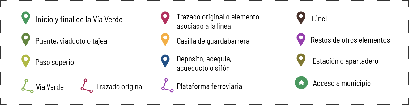
On this route, the following elements are indicated:
- In green, the current greenway route.
- In red, sections of the original Ojos Negros railway line, where it deviates from the current greenway route.
- In sky blue, the section from Albalat dels Tarongers to Sagunto, currently up for tender.
- More than 225 landmarks, including entrances to the municipalities on the greenway route.