.svg)


A novel methodology used in deserts confirms that the beaches in the south of Valencia lost 70% of their surface in the last 30 years
- Scientific Culture and Innovation Unit
- January 11st, 2024

Beaches in the south of Valencia (aerial view).
Researchers from the Cavanilles Institute of the University of Valencia (UV) reveal in an article published in the journal Urban Science that the surface area of three beaches south of the port of València (Pinedo, El Saler and La Garrofera) has increased from 170 hectares of sand in the decade of the 90s to 43 in 2022. The methodology, with satellite images, is used to know the volume of sand in deserts and here it has been applied for the first time to beaches. It is also noted that the greatest reduction was after the expansion of the port between 2010 and 2012, and that the restoration in 2023 has increased the sand surface to 112 hectares.
“This methodology fills an important gap in current research. To date, specific monitoring of the sand layer on beaches using spectral indices designed for sand dunes has not been implemented. This novel application in coastal contexts opens a new perspective in the field of research”, explain Juan M. Soria, Rebeca Pérez González and Juan Víctor Molner Polit, researchers at the Cavanilles Institute of Biodiversity and Evolutionary Biology.
The study shows a direct relationship between the expansion of the Port of Valencia with the creation of the Juan Carlos I Marina Real and the preparation for the America’s Cup tests and the reduction of beach surface area. Due to the dynamics of marine currents (north-south) in this part of the Mediterranean, the beaches in the north of the large infrastructures grow, and those in the south lose sand. The study area includes approximately 8 km from the current mouth of the Turia River, south of the port of Valencia, to the Gola de Pujol.
Thus, the images from the Landsat-5, Landsat-8 and Sentinel-2 satellites confirm how the maintenance and improvement work from the years 2004-2010 as a result of LIFE projects “managed to artificially maintain the three beaches, until the new expansion of the port wasted this effort”, explains Juan M. Soria, also a professor at the Department of Microbiology and Ecology at the University of Valencia.
The aerial images also show that from 2013 to 2022, as a consequence of the effect of the expansion of the port and the reduction of rehabilitation activities in the area, there was a reduction of approximately 90 hectares of sand. Thus, between July 2013 and the same month of 2014, according to Landsat 8 observation, the sand surface was reduced from 54.63 hectares of sand to 37.26 on Pinedo beach; from 37.08 to 23.04 in El Saler; and from 47.61 hectares to 31.23 on La Garrofera beach.
On the contrary, the restoration actions at the end of 2023, with the contribution of sand, have made it possible to increase the surface area, which has gone from 22.91 hectares to 42.49 hectares in Pinedo between September 7 and November 6. from 9.30 to 38.64 in El Saler, and from 11.73 to 31.77 in La Garrofera.
The images also show that, at the southern end of the restored area, in the Gola de Pujol, the construction of the northern dike has facilitated the settling of sand on both sides.
The work used 11 images for the period 1984-2013; 8 for the 2013-2015 phase and from 2015 to 2023 15 images have been used. The volume of sand was obtained by calculating the number of pixels that the sand occupied in each image, according to the spatial resolution of each satellite: 900 m2 in the cases of Landsat 5 and Landsat 8 and 100 m2 in the case of Sentinel-2. Thus, the sand surface was estimated, which was converted to hectares to make the magnitudes more understandable. NDSAI indices were used with Landsat-5 satellite images and NDESI for Landsat-8 and Sentinel-2. They were not originally designed for beaches, but to calculate the surface of desert dunes. Another normalised sand index (NSI), for other temperate regions with more variation in sand throughout the year, gave better results than those of this study, although the authors highlight the use of the former due to the characteristics of the Mediterranean climate, transitioning to desert climate depending on the areas.
Article: Molner, J. V.; Pérez-González, R.; Soria, J. M. Rehabilitation of Urban Beaches on the Mediterranean Coast in Valencia (Spain) Observed by Remote Sensing. Urban Sci. 2024, 8, 3. https://doi.org/10.3390/urbansci8010003
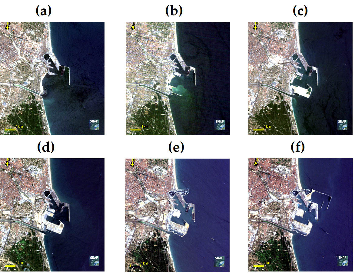
Figure 1. Images showing the evolution of the Port of Valencia at different times. Landsat-5 image data: (a) 26-Jun-1987, (b) 9-July-1992, (c) 7-July-1997, (d) 24-Jun-2004, (e) 3-July -2007, (f) June 28, 2011.
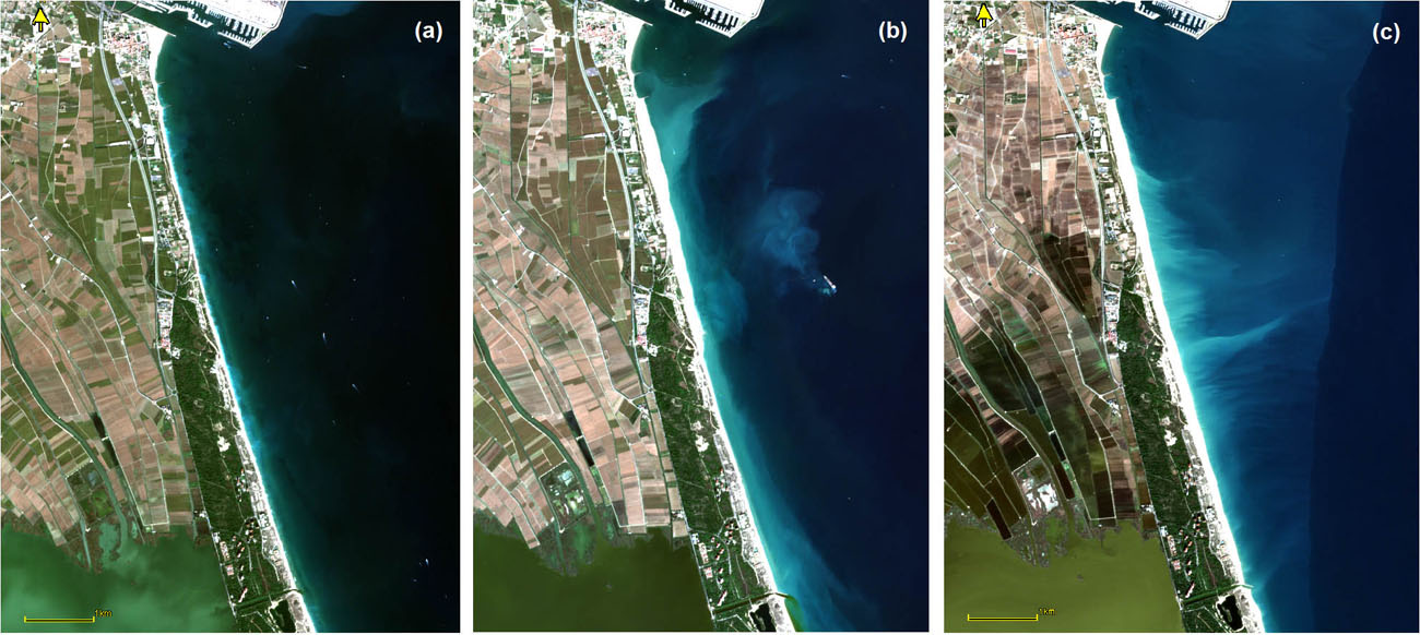
Figure 2. RGB Sentinel-2 images of the regeneration of the study beaches: (a) 1-Nov-2022 before the last rehabilitation; (b) 2-Oct-2023 during rehabilitation; (c) 6-Nov-2023 after rehabilitation.
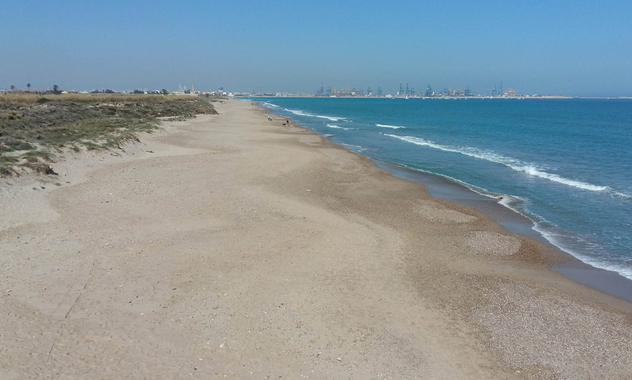
Annex photo caption: El Saler beach in 2018, with the Port of Valencia closing the horizon.


Tags
Covid
Culture
Studies
Institutional
Organisation
People
Research, innovation and transfer
University and Society
Living at the University